
Grassy karst ridge falling away to layered forested ranges in the distance at Tengu Kogen, Kochi
Step-free
Not step-free
Flat to 35 degrees over earth, steps and leaf litter
The main road
Stewartia forest road
ヒメシャラ林ロード · 4.5 km (2.8 mi) one way
Open
Year-round
Colour peaking late October
Nearest station
Susaki
JR, then about 55 min by bus
The record
What you need to go
Open season
Open year round. New leaves in spring, deep shade in midsummer, color peaking late October, snow and a sea of clouds below in winter
Getting there
JR Susaki, then a Kōchi Kōryō Kōtsū bus to Nitta (新田), about 55 minutes, and a change. By car it is about 80 minutes from the expressway
Fees
Guided walks are priced per walk for up to ten people: ¥5,000 (about $33) for the short courses, ¥8,000 (about $53) and ¥10,000 (about $67) for the long ones. No therapy bentō
Onsen
No hot spring is named. The lodge on the plateau has a bath with a view
The walk
Main trail
The stewartia forest road (ヒメシャラ林ロード), about 4.5 km (2.8 mi) one way to the fissure, two hours down and three back up
All trails
3 trails, about 1 to 4.5 km (0.6 to 2.8 mi) one way, 45 minutes to five hours, on walkways laid with hinoki chips
The step-free road
Barrier-free is marked no. Slopes run from flat to 35 degrees over earth, built steps and leaf litter, although the lodge has one accessible room
The forest
Forest type
A limestone plateau on the Shikoku Karst from 1,000 to 1,485 m (3,281 to 4,872 ft), grazed in summer and silver with pampas grass in autumn
What grows
Beech · Stewartia · Mizunara oak · Zelkova · Larch · Nikko fir · Winter hazel · Maples · Horse chestnut
What lives
Chestnut tiger butterfly, miyama stag beetle and a small firefly. Blue-and-white flycatcher, narcissus flycatcher, skylark, Japanese squirrel, raccoon dog
Certified since
2008
All figures updated 5 October 2026
The forest, before the facts
There is a crack in the ground on top of a mountain in western Kōchi, and it is a national natural monument. It has two names, Ōhikiwari and Kohikiwari (大引割・小引割), the great split and the small split, and it is said to have been opened by a great earthquake before recorded history. The walk to it takes about two hours going down, through stewartia forest. Coming back up takes three.
Above the crack is a limestone plateau, 1,000 to 1,500 meters (3,281 to 4,921 ft) up, stretched along the border of Kōchi and Ehime. In summer, cattle graze it. In autumn it turns silver with pampas grass. And at its highest point, 1,485 meters (4,872 ft), there is a stand of old forest called Tengu no Mori (天狗の森), the tengu’s wood.
The Forest Therapy Society calls this the highest forest therapy base in Japan. On a clear day, it says, you can see Shikoku whole from up here: Cape Muroto to the east, the Ashizuri peninsula to the south, Uwajima to the west, and the Ishizuchi range to the north.
Five reasons to come
The highest forest therapy base in Japan, by the Society’s own claim.
A walk down to a crack in the earth that is a national monument.
Beech, stewartia and larch on a limestone plateau above the clouds in autumn.
Paths laid with hinoki chips, to spare the ankles and knees.
A lodge with glass-roofed rooms and a planetarium, for the stars after the walk.
A plateau on the roof of Shikoku
The official name for the base is long: the Tengu Plateau Natural Recreation Forest of the Shikoku Karst (四国カルスト天狗高原自然休養林). Its tagline translates roughly as a refreshing corridor in the sky. The town it sits in is Tsuno, in Kōchi.
The Shikoku Karst is one of Japan’s three great karst landscapes, a limestone plateau about 25 kilometers (16 mi) long from east to west, sitting at around 1,400 meters (4,593 ft). The visitor center up there explains the karst’s formation and the animals and plants that live on it.
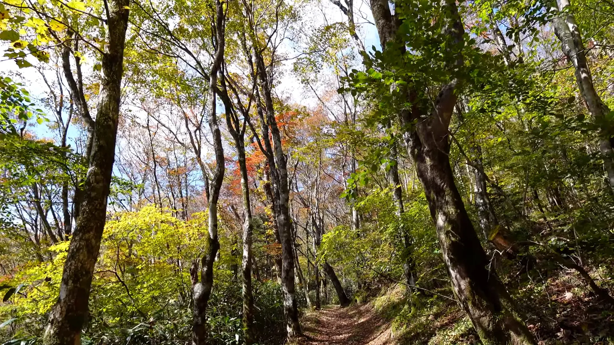
The therapy road runs for six kilometers along the ridge, almost all of it like this.
And there is a fact about water that gives the plateau a larger role: the Shikoku Karst feeds both the Shimanto and the Niyodo river systems. Two of Shikoku’s rivers draw their water off this ridge.
Two dates for one certificate
The Society gives Tsuno’s certification year as 2008, and the town gives the month: April 2008, as a forest therapy base. But the Forestry Agency’s announcement of the very first round of certifications, dated 18 April 2006, lists Tsuno too — and not as a base. It lists the Tengu Plateau recreation forest among four certified therapy roads, a separate and smaller category.
The two are not necessarily in conflict. A place certified as a road in 2006 may well have become a base in 2008. Nobody has said so in print, so both years stand.
The 2006 announcement’s one line on Tsuno is worth having in its own right. It describes a karst plateau with a 360-degree panorama, at the highest point of its kind.
The word road has not quite gone away. Travel pages for the plateau still call it the highest therapy road in the country, laid with hinoki chips, with paid guides available. So the same ground is described today as Japan’s highest base and as Japan’s highest road, and was certified as a road in 2006. Both superlatives belong to whoever wrote them.
Three roads
Three roads are certified. The first, the larch forest road (カラマツ林ロード), is about 1 kilometer (0.6 mi) one way, and it is the one recommended for first-timers, with plenty of plants, insects and small birds to meet.
The second, the stewartia forest road (ヒメシャラ林ロード), is about 4.5 kilometers (2.8 mi) one way, for experienced walkers. Its destination is the crack, a fissure in the earth designated a national natural monument.
The third, the Tengu forest road (天狗の森ロード), climbs to the highest point on the plateau, 1,485 meters (4,872 ft), hiking through primeval forest with wildflowers to look for.
And there is one detail about the paths that matters for anyone with old knees: the walkways are laid with hinoki chips, which take the strain off ankles and knees.

At 1,400 meters on a limestone ridge, the cloud does the watering.
The trees
The conifers listed are larch and the Nikko fir; the broadleaves are beech, mizunara oak and zelkova. The plateau’s characteristic plants are beech, stewartia and the akebono azalea.
And then there is one line that is not a fact so much as a feeling: the stewartia groves along the therapy road, it says, feel divine. That is all it says, and you can go and see whether you agree.
Two wildflowers get named as well, hitorishizuka and hinashajin, which bloom through the seasons.
Rare plants on the grassland
The prefecture’s own papers on the Shikoku Karst natural park add what the forest therapy pages do not: the plateau’s rare plants, and the pressure on them. The himeyuri lily (ヒメユリ) is listed as endangered. Aosuzuran is one whose extinction is feared. And kinseiran has already disappeared from the area.
The same papers describe the work of keeping the grassland open: regular controlled burning, problems with plant poaching, and an introduced species that has to be pulled out. They also record the completion, in November 2022, of a 1,470-meter (0.9 mi) trail.
None of this is on a therapy road. It is the grassland the roads begin from, and a reason to stay on the path.
What lives here
The official description of the larch road mentions insects and small birds without naming them. The town’s own forest therapy guidebook, published in 2023, names them.
Among insects: the chestnut tiger butterfly, the miyama stag beetle and a small firefly. Among birds: the blue-and-white flycatcher, the narcissus flycatcher and the skylark. Among mammals: the Japanese squirrel and the raccoon dog.

The ridge is narrow enough that both sides drop away from the path.
And cattle, grazed on the plateau in summer. It is a short list for a plateau this size, and nobody says which animal belongs to which road. But it comes from the people who run the walks, which is better than nothing.
The flowers, by the town’s count
The town’s list of trees is longer than the Society’s: beech, stewartia, mizunara oak, zelkova, kirishimamizuki winter hazel, maples, horse chestnut and larch. Its list of flowers is longer still: akebono azalea, hitorishizuka, Shikoku violet, woodland peony, mountain hydrangea, kirengeshōma, hankaisō, sasa lily, himeyuri lily and gentian.
One of those is a plant the prefecture worries about. The himeyuri lily is on both lists, and the prefecture calls it endangered. Seeing it, if you do, is a reason to leave it exactly where it is.
Guides and prices
Four guided plans are published, each priced per walk for a group of up to ten people with one guide. The larch forest course, 1 kilometer (0.6 mi) out and back in about ninety minutes, is ¥5,000 (about $33). A plateau course of 3 to 4 kilometers (1.9 to 2.5 mi), in a choice of forty-five, sixty or ninety minutes, is also ¥5,000.
The Tengu forest course, 7 kilometers (4.3 mi) in about four hours, is ¥8,000 (about $53). The stewartia and fissure course, 4.5 kilometers (2.8 mi) one way and about five hours there and back, is ¥10,000 (about $67).
For a group of ten on the long course, that is ¥1,000 (about $7) each.
The town’s 2023 guidebook prints a different pairing.
It lists four courses: the larch course and a stewartia course, each 1 kilometer (0.6 mi) one way and ninety minutes there and back, at ¥5,000; the plateau course at ¥5,000; and a Tengu forest course of 4.5 kilometers (2.8 mi) one way, five hours there and back, at ¥10,000. The Society gives that 4.5 kilometers and that ¥10,000 to the stewartia and fissure course instead, and 7 kilometers and ¥8,000 to the Tengu forest. Both pairings are in print. Ask which walk you are booking before you pay for it.

Late October on the Shikoku Karst, which turns later than the mainland.
There is no therapy bentō.
Two measurements for the long walks
The times for the two long walks differ depending on who is counting. The Society gives the stewartia and fissure course as about five hours there and back. Travel guides give the walk from the old lodge down to the great split as about two hours going down and three coming back — the same five hours, divided.
For the Tengu forest, the guided course is 7 kilometers (4.3 mi) and four hours, while the walk from the lodge to the top is given as about forty minutes. Those are different walks: one a guided loop, the other a direct climb.
The seasons
The four seasons are written simply. Spring is new leaves and the light coming through them. Summer is deep green and a cool wind, and the guides add that even in midsummer you can walk under dappled shade.
Autumn is color, and in autumn and winter you may see a sea of clouds pooled below the plateau. Add the silver pampas grass. The usual peak for color is late October, with beech, stewartia, akebono azalea and maples among the trees that turn. Winter is snow scenery and the feel of new snow underfoot, depending on how much has fallen.
The Society’s barrier-free answer is no. Ask before you plan anything on wheels.
On wheels
Ask the lodge four things.
How wide is the surfaced path on the larch road, in centimeters? Is there a step at the trailhead? What is the surface between the parking area and the start? And is there an accessible toilet at the lodge or the visitor center?

Thin soil over limestone, which keeps the trees small and the light in.
The town’s guidebook describes the ground more fully, and less gently: elevations from 1,000 to 1,484 meters (3,281 to 4,869 ft), slopes from flat to 35 degrees, and surfaces of earth, built steps and fallen leaves. It also lists one accessible guest room at the lodge, among 23 Japanese-style and two Western-style rooms.
The hinoki chip surface is the place to start. Chips are soft underfoot. Whether they are passable on wheels is a different question.
Where to stay
The contact for this base is not a town office but the lodge itself: Hoshifuru Village TENGU (星ふるヴィレッジTENGU), on 0889-62-3188. It has rooms with views of the stars, some with glass ceilings, in six types, and a planetarium.
The lodge stands at 1,350 meters (4,429 ft), and was formerly the public lodge Tengusō. The therapy road starts there, and it has been chosen for both the hundred best forest-bathing forests and the hundred best walking paths in Japan.
Three more places nearby. Karst Terrace (カルストテラス), the visitor center, introduces the karst’s history, animals and plants, sells drinks and sweets, and rents electric bicycles. Forest Adventure Kōchi is an adventure park with six ziplines, a Tarzan swing, slacklines and suspension bridges. And the Yoshimura Toratarō house (吉村虎太郎邸) is the restored birthplace of a man of the Meiji Restoration, one of the Tenchūgumi, with free entry, exhibits and light meals.
Stars, and three heights for one lodge
The lodge’s selling point is the sky: rooms with glass ceilings, and a planetarium with four showings a day, at 11:00, 12:30, 14:00 and 15:30, each about forty-five minutes. Admission is ¥800 (about $5) for sixteen and over, ¥400 (about $3) for ages six to fifteen, and free for five and under. The point is that you can still see stars on a cloudy night.
The lodge’s altitude is published three ways.
One source says 1,350 meters (4,429 ft). The prefecture’s tourism listing says 1,355 meters (4,446 ft). A feature article on the same prefectural site says 1,485 meters (4,872 ft), which is the height given elsewhere for the top of the Tengu forest and not for the lodge. The first two agree to within five meters (16 ft); the third is almost certainly the summit figure in the wrong place.
Inbound, and getting there
The Society’s answer for visitors from abroad is no. That does not mean you cannot come. It means the base has not told the Society it is ready for you, so if you have no Japanese, ask in advance what language the walk will be in.

Above the treeline it is all grass and bare limestone for twenty-five kilometers.
There is a route by public transport: a Kōchi Kōryō Kōtsū bus from JR Susaki station to Nitta (新田), about fifty-five minutes, and then a change. By car it is about 52 kilometers (32 mi) from the Susaki-nishi exit of the Kōchi Expressway.
The drive from Kōchi city is about two hours and ten minutes, by Route 56, then Route 197 from Susaki, then Route 439 from Nitta in Tsuno. From Kōchi Ryōma Airport it is about two and a half hours on the expressway.
The drive from the expressway is given three ways.
About an hour and twenty minutes from the Susaki exit. About eighty minutes from Susaki-higashi. And 52 kilometers (32 mi) from Susaki-nishi.
One source gives a free parking lot for 100 cars; the town gives the lodge’s parking as 200. The lodge stays open in winter, with snow, and rents ski equipment.
And the lodge is about thirty minutes by car from the town of Yusuhara, which is the Tarogawa base. The two make a natural pair: a plateau on the Shikoku Karst, and a mountain town whose therapy walk follows an irrigation channel about a century old.
The shape of a stay
Arrive in the afternoon and walk the larch road before dinner, a kilometer (0.6 mi) each way on hinoki chips. Eat at the lodge. Go up to the planetarium, or look up through the glass.
In the morning, if the air is clear, climb to the Tengu forest and look for Cape Muroto. Then take a guide down the stewartia road to the crack in the earth, two hours down, three hours back. The plateau is high enough that the Society says clouds pool below it in autumn. If they do, you will be walking above them.
Nearby and alike

Kōchi · Certified 2007
Yusuhara (Tarogawa)
A level walk beside a hundred-year-old irrigation channel, fir and hemlock at Kubotani, and a bath in a park built of local cedar.

Miyazaki · Certified 2006
Hinokage
One of Japan’s first six forest therapy bases, laid along an old railway, a logging trolley line and 1850s stone terraces.

Ōita · Certified 2012
Ōita
Ten certified roads within an hour of Ōita, from a flat museum loop to a five-star ridge, with guides at ¥3,000 a group.

Choosing a Base
Eight forests, from Kusatsu to Yakushima. Which fits your days, your season and the onsen waiting after.

Certification
Over sixty Japanese forests hold a therapy certificate. What the test involves, and what it does not promise.

The Walk
A measured forest walk is about thirty minutes and no destination. Here it is, sense by sense, step by step.
Verified by The Japan Onsen Society
Sources
森林セラピーソサエティ「高知県 四国カルスト天狗高原自然休養林」— https://fo-society.jp/facility/tsuno/ (認定 2008年; barrier-free 否, inbound 否; 1,485 m; 3 roads; hinoki chips; ヒトリシズカ, ヒナシャジン; tree fields; ヒメシャラ note; four seasons; four plans and prices; “日本で一番標高の高い森林セラピー基地”; views of Muroto, Ashizuri, Uwajima, Ishizuchi; 四万十川・仁淀川; lodge, カルストテラス, フォレストアドベンチャー・高知, 吉村虎太郎邸; contact)
林野庁「第1期(平成17年度)認定箇所一覧」平成18年4月18日 — https://www.rinya.maff.go.jp/puresu/h18-4gatu/0418b2.pdf (津野町『天狗高原自然休養林』listed as セラピーロード; 360-degree panorama, highest karst)
津野町「天空の爽回廊 GUIDE BOOK」(2023) — https://town.kochi-tsuno.lg.jp/tsunobura/contents/wp-content/uploads/2023/03/tenku_no_sokairo.pdf (平成20年4月 base; four courses and prices; 1,000–1,484 m; slopes; surfaces; trees and flowers; fauna: アサギマダラ, ミヤマクワガタ, ヒメボタル, オオルリ, キビタキ, ヒバリ, ニホンリス, タヌキ; lodge 82 guests, 23+2 rooms, 1 accessible room, 200 parking; winter operation; airport 2 h 30 min)
高知県「四国カルスト」— https://www.pref.kochi.lg.jp/doc/karusuto/ (park spans 仁淀川町・津野町・梼原町; Kōchi city ~2 h 10 min; route)
高知県 committee document — https://www.pref.kochi.lg.jp/doc/2023080300035/file_contents/1kai_shiryou.pdf (ヒメユリ endangered; アオスズラン; キンセイラン gone; burning; poaching; 1,470 m trail, Nov 2022)
高知県観光 visitkochijapan.com — lodge · feature (1,355 m; planetarium times and prices; Susaki IC ~1 h 20 min; Yusuhara 30 min; feature article gives 1,485 m)
たびんぐ — ko0087 · ko0124 [CITABLE, secondary] (1,000–1,500 m; three great karsts; 25 km; 大引割 earthquake origin; cattle; susuki; lodge at 1,350 m; 40 min to 天狗の森; 2 h down / 3 h up to 大引割; ~1,400 m; 森林浴の森100選・遊歩百選; bus and IC access)
ウォーカープラス「天狗高原の紅葉」— https://koyo.walkerplus.com/detail/ar0939e154774/ [CITABLE, secondary] (late-October peak; “highest セラピーロード”; 100 free spaces; Susaki-higashi IC ~80 min)
Verified: 2026-10-05