
A path winding through cedar with bright new undergrowth on both sides.
Step-free
Step-free
Monorail for wheelchairs, bookable in advance
The main road
Tokei trail
登計トレイル · 1.3 km (0.8 mi) · part paved
Open
Year-round
Lakeside road closed December to March
Nearest station
Okutama
JR Ōme Line, about 2 hours from Shinjuku
The record
What you need to go
Open season
Open year round except the lakeside road, closed December to March. Cherry round the lake in mid-April, color in the gorges from late October
Getting there
Okutama (奥多摩駅) on the JR Ōme Line, about two hours from Shinjuku with one change. The Tokei trail is 20 minutes on foot from the station
Fees
The forests are free. A guided walk on the Tokei trail is ¥20,000 (about $133) alone, ¥11,000 (about $73) each for two, down to ¥6,000 (about $40) each for six or seven. Lunchbox ¥1,000 (about $7)
Onsen
Moegi no Yu (もえぎの湯), ten minutes on foot from the station, with an open-air bath over the Tama river
The walk
Main trail
The Tokei trail (登計トレイル), 1.3 km (0.8 mi) with a 50 m (164 ft) rise, part paved and part wood chip, built for forest therapy and nothing else
All trails
5 trails, 1.3 to 12 km (0.8 to 7.5 mi), climbing 36 to 264 m (118 to 866 ft)
The step-free road
The Tokei trail is barrier-free, with a monorail for wheelchairs booked in advance. About 2 km (1.2 mi) of the lakeside road is barrier-free as well
The forest
Forest type
A town 94 percent forest at the head of the Tama, much of it kept as waterworks source forest since 1901 because Tokyo drinks from it
What grows
Cedar · Hinoki cypress · Wild cherry · Maples · Oaks, with katsura, horse chestnut and mizunara giants up the Nippara valley
What lives
Asian black bear and sika deer, whose browsing has thinned the understory. Japanese marten and serow. Land leeches on the lake road in the wet months
Certified since
2008
All figures updated 5 October 2026
The forest, before the facts
Count the trunks you cannot get your arms around. A national survey did, in 1999 and 2000, measuring every tree in Japan 3 m (10 ft) or more around, and the town with the most of them was not on Yakushima or in the Kiso valley but in Tokyo: Okutama (奥多摩町), with 891. The train from Shinjuku takes two hours and ends at the top of the Tama river. Twenty minutes’ walk from the platform, past the sound of the Hikawa gorge, the path turns to wood chips under cedar and the valley drops away on the left.
Up a side valley by bus, and fifteen minutes of climbing off the stop, a single cypress has stood for about a thousand years, 34 m (112 ft) tall, and the people below it call it the thousand-year hinoki. The air in the gorges smells of wet rock and cedar resin, and the river is always somewhere under the sound. Come on a weekday morning. The city is behind you by Tachikawa, and by Ōme it is gone.
Five reasons to come
The most giant trees of any town in Japan, inside Tokyo.
A thousand-year cypress, fifteen minutes up from a bus stop.
Japan’s first purpose-built therapy road, on wood chips, twenty minutes from the station.
A forest kept since 1901 because the capital drinks from it.
A hot-spring bath ten minutes’ walk from the last train.

Plantation cedar, grown for Tokyo's timber and never cut.
What you walk into
“Okutama, the forest healed by giant trees” (おくたま巨樹に癒される森) is the Forest Therapy Society’s name for the certified forest in Okutama, the westernmost town of Tokyo, where the Tama river comes down out of the mountains. It was certified in April 2008, the first base in the capital, and the Society lists five roads. The town is 94 percent forest, by the Society and the Tokyo government both, and 4,369 people lived in it on the first day of 2026.
The five roads are not five versions of one walk. The Tokei trail (登計トレイル), the fragrance path, 1.3 km (0.8 mi) with a rise of 50 m (164 ft), is the one the Society and the operator both call Japan’s first road built for forest therapy and nothing else, surfaced in part with pavement and in part with wood chips, with a clearing for yoga and seated meditation and a small station where the guided walks stop for herb tea. The lakeside Ikoi no Michi (奥多摩湖いこいの路) runs 12 km (7.5 mi) along the north shore of the reservoir from the dam to the Yama no Furusato Mura (山のふるさと村) nature center, unpaved, with about 2 km (1.2 mi) of it barrier-free, and a total rise of 36 m (118 ft).
The old road, Okutama mukashi-michi (奥多摩むかし道), is 9 km (5.6 mi) of the Edo-period highway from the station to the lake, part unpaved, climbing 264 m (866 ft) past wayside shrines and old trees. The Hatonosu gorge path (鳩ノ巣渓谷遊歩道) is 2.5 km (1.6 mi) of unpaved gorge path along the Tama and the Shiromaru lake, with a rise of 68 m (223 ft). The Kawanori valley path to Hyakuhiro Falls (川苔谷・百尋ノ滝探勝路) is 1.8 km (1.1 mi) one way up a mountain stream to a waterfall, 170 m (558 ft) of climb, which the operator labels a proper mountain course needing proper gear.
The trees are planted cedar and cypress over the broadleaves that were always here: wild cherry, maples and oaks, with katsura, horse chestnut and Mizunara oak among the giants of the Nippara valley, where the Tokugawa shogunate kept the forest as a reserved mountain no one could cut. The town’s slogan is the town of giant trees and clear streams, and the tourism association dates it to the newspaper and television coverage that followed the 2000 survey.

The canopy closes over almost everything here.
The giant trees
Okutama has more of them than any town in Japan. Not Yakushima, not the Kiso valley — a town at the end of a Tokyo commuter line. The Ministry of the Environment measured every tree in the country three meters (10 ft) or more around, found 64,479, and Okutama held 891 of them, more than anywhere else.
Two are worth the morning on their own.
The Kurasawa cypress stands on the slope above the Nippara road: 34 m (112 ft) tall, 6.3 m (21 ft) around, reckoned at a thousand years, and the largest cypress in the Kantō. The bus from the station takes eighteen minutes and the climb from the stop takes fifteen or twenty. Go early, when the light comes through sideways and there is nobody else on the path, and stand under it for a while before you reach for anything.
The three-trunked cedar at Oku-Hikawa shrine is beside the station, which makes it the easiest giant tree in Tokyo to get to — 50 m (164 ft) tall, 7.5 m (25 ft) around, six and a half centuries, and about four minutes from the ticket gate.
For the rest there is a hall. The Nippara Forest Hall, up the valley, keeps records of giant trees from across the country. Ten to five April through November, ten to four in winter, closed Mondays, ¥200 (about $1.30).

Water comes off these slopes year round.
Why the forest is here: the water
Okutama’s forest was not kept for walking. In 1901 the Tokyo prefectural government, alarmed at the state of the mountains above its water supply, took over former imperial forest at the head of the Tama and began managing it as waterworks source forest. The city council approved a management plan in 1910 and opened a source-forest office the same year, and in 1950 it bought about 4,780 ha (11,800 acres) of private forest in the former village of Kori. Today the Tokyo waterworks bureau manages 25,666 ha (63,400 acres) across four municipalities, 10,071 ha (24,900 acres) of it in Okutama, between 350 and 2,100 m (1,150 and 6,900 ft), and 68 percent of it is natural forest rather than plantation.
The reservoir at the top of the therapy roads is the same project. The Ogōchi (小河内) dam, which made Lake Okutama, is the largest dam in Japan built solely for drinking water, and the waterworks bureau reports its basin as 3.8 percent silted. The Ikoi no Michi runs along its shore, and the old road ends at it.
Not every valley is old forest. The Kawanori (川苔) catchment that the fifth therapy road climbs, 432 ha (1,070 acres) at around 800 m (2,620 ft), is 96 percent plantation and 95 percent conifer by the Forestry Agency, which lists it among its hundred source forests for the 9,331 m³ (2.5 million gallons) of water it yields a day. A walker who wants the giants goes to Nippara; a walker who wants a waterfall at the end of a cedar valley goes up the Kawanori.
What the certificate measures, and what it does not
The Society certifies a road against a standard it publishes in words and not in numbers. A base must have two or more paths that are wide, gently sloped and easy to walk, together with lodging; a single such path can be certified as a road. Before certification the Society requires a field experiment on the ground itself, measuring heart-rate variability, blood pressure and pulse, mood by the POMS questionnaire, and the forest’s impression by the semantic differential method, run between July and October of the application year. No width in meters and no gradient in percent is published, and no Okutama result from the 2008 experiment has ever been made public.

The Tama cuts hard through here, two hours from Shinjuku.
What the operator publishes instead is the difference between a road’s high and low points, and a surface, and those are the measurements above. The Tokei trail’s 50 m (164 ft) over 1.3 km (0.8 mi) is the gentlest, and the barrier-free section is served by a monorail for wheelchairs, paid and booked in advance. The Ikoi no Michi’s 36 m (118 ft) is spread over 12 km (7.5 mi), the flattest ground of the five, with about 2 km (1.2 mi) barrier-free from the dam. The old road’s 264 m (866 ft) comes with the Tokyo government’s own warning on its walking maps, that some of it is steep and unpaved; the Kawanori path is a mountain trail and says so.
Where exactly the barrier-free sections end, in meters from the trailhead, is not published for either road. A family planning on wheels should book the Tokei monorail and ask the operator that question in those words.
Deer, bears, leeches, and who you will meet
Tokyo’s mountains hold a bear population, and the prefecture’s rangers say so plainly. In August 2019 sightings of the Asian black bear rose on Mount Kawanori (川苔山), the mountain above the fifth therapy road, and the tourism association’s newsletter in a more recent year reported more sightings than usual, including near the villages. The rangers also name the Japanese marten, which Okutama people call tenmaru, and the visitor center at the station carries images of the Japanese serow, the red-flanked bluetail and the white shiroyashio azalea as the valley’s own. Nobody publishes a list of the songbirds of the gorges.
The animal that has changed the forest is the deer. The Tokyo government’s management plan records Okutama’s cull of sika deer rising from ten animals a year to 426 in fiscal 2004, and a former mayor put the herd on Mount Kumotori (雲取山), the prefecture’s highest peak, at some two thousand, with overgrazed slopes and landslides behind the numbers. The visitor center posted notice of a cull in late September 2026. The understory a walker sees in Okutama is a deer-browsed understory, and the ranger pages are honest about it.
Then the smallest thing. A volunteer monitoring network confirmed the Japanese land leech on the lake road in a survey of June 2009, the only Okutama road on its list, and leeches follow deer. That is one dated survey, and it is specific: on the lake road in the warm wet months, from the rains of June through the autumn rains, wear long pants tucked into socks and check your ankles at the end. The town publishes no leech notice of its own, and none of the other four roads appears on the monitoring list.
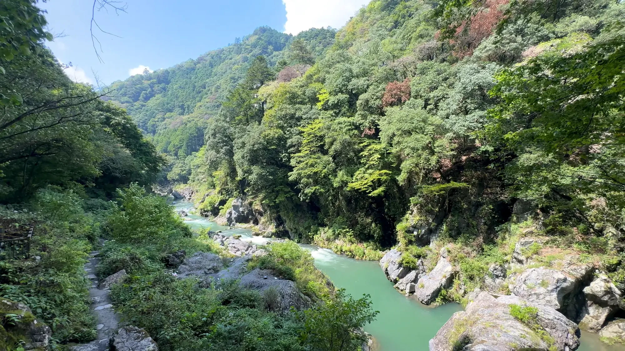
The river that gives the valley its name.
The year in the gorges
Spring comes up the valley from the lake. Four thousand cherry trees ring the reservoir and flower in mid-April, and the new leaf fills the gorges from late April into the middle of May. Pink azalea was planted along the Tokei trail, and it opens with the leaf. The Ogōchi weather station, at 530 m (1,740 ft) above the lake, averages 1.3 °C (34 °F) in January and 23.2 °C (74 °F) in August, with 1,624 mm (64 in) of rain a year, most of it in the rainy season and the typhoon months.
Summer is the river. The Society lists river play, the festivals and the fireworks, which is a fair account of what the town is for in August, and the shade in the gorges is deep. It is also the leech season on the lake road and the thick season for insects everywhere, and a July afternoon on the old road is not the forest’s best face.
Autumn is. The three gorges, Hikawa (氷川) below the station, Hatonosu (鳩ノ巣) and the lakeshore, turn from the last week of October to the middle of November, and the Society’s one-word note for the season is autumn color. Winter closes only the lake road, from December to March; the other four stay open, the streams freeze at their edges, and the Society’s note for the season is winter scenery and the stars, which at the end of a railway line two hours from Shinjuku is a real thing to come for.
Taking a guide, or not
Nobody needs a guide on the Tokei trail, which was built so that nobody would. For those who want one, the operator, the Okutama regional promotion foundation (一般財団法人おくたま地域振興財団), runs a standard plan on that road priced per head by the size of the party: ¥20,000 (about $133) alone, ¥11,000 (about $73) each for two, ¥9,000 (about $60) for three, ¥8,000 (about $53) for four, ¥7,000 (about $47) for five, and ¥6,000 (about $40) for six or seven, with one guide to every seven walkers, bookings asked for two weeks ahead through the web form, a lunchbox for ¥1,000 (about $7) more, and blood-pressure measurement offered as an option. A two-day plan pairs the walk with forest yoga and a night in the town. Corporate groups of six to twenty are quoted ¥6,000 (about $40) a head for a 270-minute program in the Forestry Agency’s case study, which also notes that the foundation sells the forest to Tokyo companies as training and welfare.
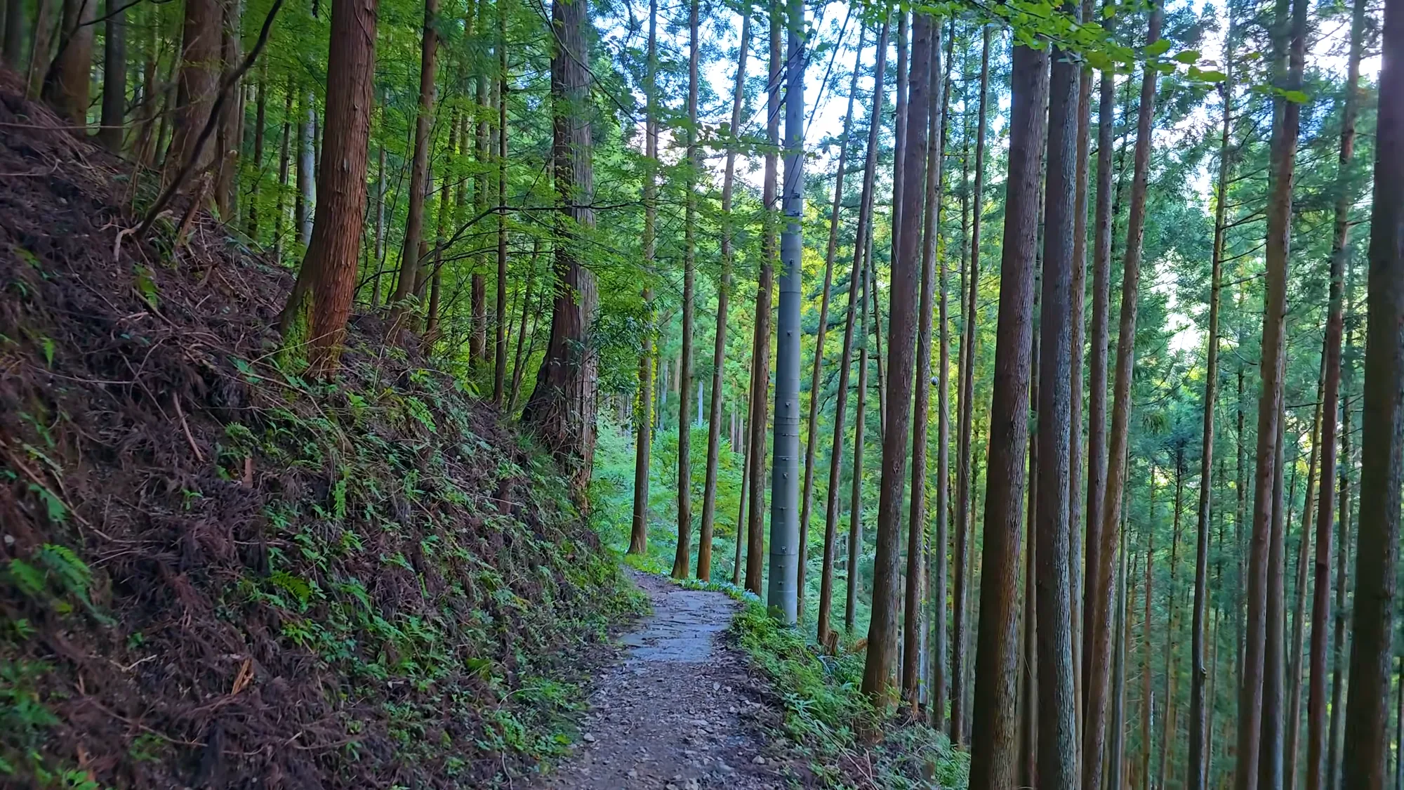
Most of the walking is contouring, not climbing.
The office is at 215-6 Hikawa (氷川215-6), a few minutes from the station, open 8:30 to 17:15 on an irregular schedule; the number of certified guides it employs is not published. Payment is by card or bank transfer. Whether the Tokei road is a loop or an out-and-back is not published; the trailhead signboard will tell you.
Getting there, and the bath after
The nearest shinkansen is Tokyo Station, which is also the answer to the question of how a visitor from abroad arrives. From there the Tokyo tourism foundation gives about 2 h 15 min: the Chūō line to Tachikawa (立川), then the Ōme line (青梅線) to its last stop. From Shinjuku it is about two hours with one change, at Tachikawa or at Ōme (青梅), and the fare was ¥1,230 (about $8) for the 64.4 km (40 mi) when this was written; the Forestry Agency’s case study promises 100 minutes on the weekend Holiday Rapid, but since the timetable change of March 2023 that train runs Shinjuku to Ōme, with the leg on to Okutama a seasonal extra, so check the date before counting on it.
From the station the first road is on foot: about twenty minutes through the Hikawa gorge to the Tokei trail. The lake is fifteen minutes by Nishi-Tokyo bus (西東京バス) toward Lake Okutama, the Kurasawa cypress eighteen minutes on the Higashi-Nippara (東日原) bus, and the bus fares are not published anywhere, so carry an IC card. Nothing about the forest needs a car.
The bath is Moegi no Yu (奥多摩温泉 もえぎの湯), ten minutes’ walk from the station, with an open-air bath over the Tama and water the operator describes as 100 percent from the Okutama spring. It opens ten to eight from April to November and ten to seven from December to March, with last entry an hour before, closes Mondays, and entry is ¥1,050 (about $7) for three hours. The source temperature is not published. There is an older story under the lake. Tsuru no Yu (鶴の湯), a spring used since the fourteenth century, was drowned by the Ogōchi dam and brought back in 1991 by pumping its three sources up from the lake bed — a sulfur spring at 29.6 °C (85 °F), now serving a handful of inns and no day-use bath.
Walk first, bathe after, and let the medical society’s thirty minutes pass between them. Then the Ōme line back down the valley, where the city reassembles itself one station at a time.
Nearby and alike

Tokyo · Certified 2007
Hinohara
The gentlest path in a 197-hectare mountain park, wood-chipped end to end to a thirty-five-meter waterfall. The only therapy lunchbox of these forests published dish by dish.

Kanagawa · Certified 2016
Hakone-Ashinoko
A flat, bright forest on the shore of Lake Ashi with its plants and birds actually counted — and a second road the town recommends because nobody goes there.

Nagano · Certified 2006
Akasawa
Four hundred years of protection, the cypress that rebuilds Ise Shrine, Japan’s first recreation forest, and the 1982 gathering that gave forest bathing its name.

Forest Bathing in Japan
Japan named forest bathing in 1982, then measured it. The practice, the places, and what the studies show.

The Science
The studies are real, small and oversold. What was measured, in how many people, and what was never shown.

Choosing a Base
Eight forests, from Kusatsu to Yakushima. Which fits your days, your season and the onsen waiting after.
Verified by The Japan Onsen Society
Sources
森林セラピーソサエティ「東京都 おくたま巨樹に癒される森」— https://fo-society.jp/facility/okutama/ (認定 2008年4月; 5 roads; species; 巨樹 1,013本; 森林率94%; 20 min walk from the station)
森林セラピーソサエティ「基地認定について」— https://fo-society.jp/authorization/ (the road criterion in words; the field-experiment measures; no numeric width or gradient)
森林セラピー基地奥多摩「セラピーロード」— https://www.okutama-therapy.com/therapy/ (five roads: lengths, 高低差, surfaces, barrier-free sections, monorail, winter closure of いこいの路)
森林セラピー基地奥多摩「プライベートツアー」— https://www.okutama-therapy.com/privatetour/ (standard plan per-head prices; one guide per seven; two weeks’ notice; lunchbox ¥1,000)
林野庁 森林サービス産業 事例集 奥多摩町 — https://www.rinya.maff.go.jp/j/sanson/kassei/sangyou/attach/pdf/area-85.pdf (平成20年4月 first base in Tokyo; corporate ¥6,000 / 270 min; Holiday Rapid 100 min)
環境省 第6回自然環境保全基礎調査 巨樹・巨木林フォローアップ調査 — https://www.env.go.jp/press/2887.html · https://www.biodic.go.jp/image/tree.pdf (definition 幹周3 m以上; 64,479 nationwide; 奥多摩町 891; 御蔵島村 649; 角館町 444)
奥多摩観光協会 きさっせ No.65 — https://okutama.gr.jp/site/kisasse/pdf/65-all.pdf (倉沢のヒノキ 樹齢1000年・34 m・幹周6.3 m, 都天然記念物; 御留山; the slogan’s origin); No.67 — https://okutama.gr.jp/site/kisasse/pdf/67.pdf (bear sightings)
東京都水道局 事業概要 (水道水源林) — https://www.waterworks.metro.tokyo.lg.jp/documents/d/waterworks/204002008068139-all (25,666 ha; 奥多摩町 10,071 ha; 1901, 1910, 1950; 天然林68%; Ogōchi largest water-only dam; 3.8% silt); 林野庁 水源の森百選 東京都水道水源林 — https://www.rinya.maff.go.jp/j/suigen/hyakusen/indivisual/260218_22.html (350–2,100 m); 川乗水源林 — https://www.rinya.maff.go.jp/j/suigen/hyakusen/indivisual/260218_23.html (432 ha; 800 m; 人工林96%; 針葉樹95%; 9,331 m³/日)
東京都福祉保健局 ウォーキングマップ 奥多摩むかし道 — https://www.fukushihoken.metro.tokyo.lg.jp/walkmap/map/detail/pdf/okutama01.pdf · okutama02.pdf (4.0 km / 80 min; 5.3 km / 120 min; steep and unpaved warning)
東京都環境局 ニホンジカ管理 資料 — https://www.kankyo.metro.tokyo.lg.jp/documents/d/kankyo/040323_siryou2-3-1- (cull 10 → 426 in FY2004); 東京都レンジャーニュース No.178 — https://www.kankyo1.metro.tokyo.lg.jp/naturepark/join/toranger/news.files/Rnews201910No178R.pdf (bears on Kawanori, August 2019; てんまる)
奥多摩ビジターセンター — https://okutamavc.ces-net.jp/ (serow, bluetail, shiroyashio; deer-cull notice 28 September 2026)
ヤマビル注意報 生息地域一覧 — https://yamabiru.sakura.ne.jp/region.html [SECONDARY] (奥多摩湖いこいの路, survey 2009-06-25)
気象庁 小河内 平年値 via weather.time-j.net — https://weather.time-j.net/Climate/Chart/Ogouchi [SECONDARY aggregator of JMA data; 1981–2010] (530 m; Jan 1.3 °C; Aug 23.2 °C; 1,623.5 mm)
東京観光財団 GO TOKYO 奥多摩 — https://www.gotokyo.org/jp/destinations/outlying-area/okutama-and-around/index.html (Shinjuku ~2 h; Tokyo Station ~2 h 15 min); spot 463 (office hours, address)
日原森林館 — http://www.kyoju.jp/ (hours; ¥200); 環境省 秩父多摩甲斐国立公園 リンク — https://www.env.go.jp/park/chichibu/link.html
奥多摩温泉もえぎの湯 — https://www.okutamas.co.jp/moegi/ (hours by season; Mondays closed; 10 min walk; 源泉100%); ジョルダン温泉 — https://sp.jorudan.co.jp/onsen/details/1531/ [SECONDARY] (¥1,050 / 3 h)
るるぶ&more 鶴の湯温泉 — https://rurubu.jp/andmore/spot/70001475 [SECONDARY] (1991 revival; 29.6 °C; no day-use); 奥多摩湖 — https://rurubu.jp/andmore/spot/80012711 [SECONDARY] (~4,000 cherry, mid-April; bus 15 min)
tabi-mag 倉沢のヒノキ — https://tabi-mag.jp/tk1366/ [SECONDARY] (bus 18 min; 15–20 min climb); 奥氷川神社の三本杉 — https://tabi-mag.jp/tk1358/ [SECONDARY] (50 m; 7.5 m; 650–700 yrs); 奥多摩駅 — https://tabi-mag.jp/tk0607/ [SECONDARY] (343 m)
東京都総務局統計部 住民基本台帳 令和8年1月1日 — https://www.toukei.metro.tokyo.lg.jp/juukiy/2026/jy26qf0001.pdf (4,369); 東京都 移住フェア 奥多摩町 — https://tokyo-tamashima-iju-fair-tour.metro.tokyo.lg.jp/assets/pdf/okutama_0629.pdf (94% forest)
ホリデー快速おくたま 2023年3月 改正 — https://pedia.3rd-in.co.jp/wiki/ホリデー快速おくたま [SECONDARY]; 駅探 新宿→奥多摩 運賃 — https://ekitan.com/transit/fare/sf-2334/st-1746 [SECONDARY] (¥1,230; 64.4 km)
Travel Voice 2022-01-14 — https://www.travelvoice.jp/20220114-150414 [SECONDARY] (wood-chip surface; herb tea station)
Verified: 2026-10-05