
Timber boardwalk crossing dark marsh water between green sedge and conifers at Shiga Kogen, Nagano
Step-free
Partly step-free
One of five roads, unnamed
The main road
Sunshine Trail
サンシャイントレール · 3.9 km (2.4 mi) · 90 min
Open
Early May – end Oct
Guided season
Nearest station
Nagano
Nagaden express bus, 70 min
The record
What you need to go
Open season
Guides work from early May to the end of October. The high moors flower in high summer, after the snow leaves
Getting there
Nagano Station, then the Nagaden express bus (急行志賀高原線) to Yama-no-Eki, 70 minutes, ¥2,500 (about $17), four a day
Fees
Parking at the Hasuike hub is free. No program or guide price is published
Onsen
Eight districts, among them Hoppō, Kuma-no-Yu and Maruike-Hasuike. There is no day-use building, so you ask an inn to let you bathe
The walk
Main trail
Sunshine Trail and Mizunashi Pond (サンシャイントレール・水無池), 3.9 km (2.4 mi), about 90 minutes, climbing 100 m (330 ft)
All trails
5 trails, 1.8 to 9.6 km (1.1 to 6.0 mi), one hour to three and a half. One of the five is barrier-free
The step-free road
The base states that one of its five roads is barrier-free, a number rather than a yes. It does not say which road, so ask before you go
The forest
Forest type
Subalpine conifer forest at the center of a national park, over seventy ponds and marshes in a headwater zone, a UNESCO Biosphere Reserve
What grows
Northern Japanese hemlock · Maries’ fir · Japanese arborvitae · Mizunara oak
What lives
not published
Certified since
2008
All figures updated 5 October 2026
The forest, before the facts
5(うちバリアフリーロード1)
Five roads, of which barrier-free roads: one.
Otari, 40 km (25 mi) west of here, prints the same parenthesis: 4(うちバリアフリーロード:1). Two villages in Nagano answer the accessibility question the way a walker would ask it. Not is this base accessible, which is unanswerable, but how many of your paths are. Almost every other certified base in Japan answers with a single character instead, yes or no, as a property of the whole base.
Two bases doing it is worth more than one would have been. It makes the parenthesis a convention rather than an eccentricity, something somebody in Nagano worked out and somebody else copied, and it proves the format was always able to carry the information.
What the five roads cross is water, at altitude, in a reserve the United Nations has certified. 志賀高原 sits at the center of the 上信越高原国立公園, ringed by peaks of the two-thousand-meter class, 2,000 m (6,560 ft) and up. The thing that defines it is not forest but water: more than seventy ponds, lakes and marshes of every size, in a headwater zone.
And the forest above them is 亜高山針葉樹林, subalpine coniferous forest, which in Japan is the highest and coldest forest there is.
Five reasons to come
One of the five roads is barrier-free, and the base says so in a number.
Seventy ponds and marshes at the top of a national park, on roads built to link them.
A UNESCO Biosphere Reserve, certified for people and nature sharing one place.

Onuma-ike is that color because of the acid coming off the volcano, not the sky.
Eight hot spring districts and ninety inns, inside one highland.
Subalpine conifer forest you can reach without climbing into it.
The number, and the second base to use it
山ノ内町 (Yamanouchi) holds this base, certified in April 2008 under the name うるわしの森 志賀高原, the Beautiful Forest, Shiga Kōgen, with the tagline 雲上のセラピーロード「みどり響く 湖沼めぐり」: a therapy road above the clouds, green resounding, a round of the lakes and marshes.
Five roads, of which barrier-free: one. No road is named. No lengths, no times, no gradients and no surfaces, so the quantified accessibility is the only concrete road fact on the entire page, which is a strange and telling priority. A base that publishes nothing about its paths still thought it worth specifying how many of them a wheelchair can use.
All four service fields are marked 可.
What the roads do is described in one sentence, and it is a good one. The five therapy roads make use of the area’s character, spread across a wide area, and are set out as varied courses that go round the primeval forest, the marshes and the lakes.
Spread across a wide area matters practically. These are not five loops from one car park. Shiga Kōgen is a large highland with roads and lifts and villages in it, and the five therapy roads are distributed across the whole of it. You will drive between them.
原生林, primeval forest, is claimed here as it is at Otari and Achi, and as at Achi it comes with no supporting species breakdown beyond four trees. The claim stands as the base’s, not as a verified fact.
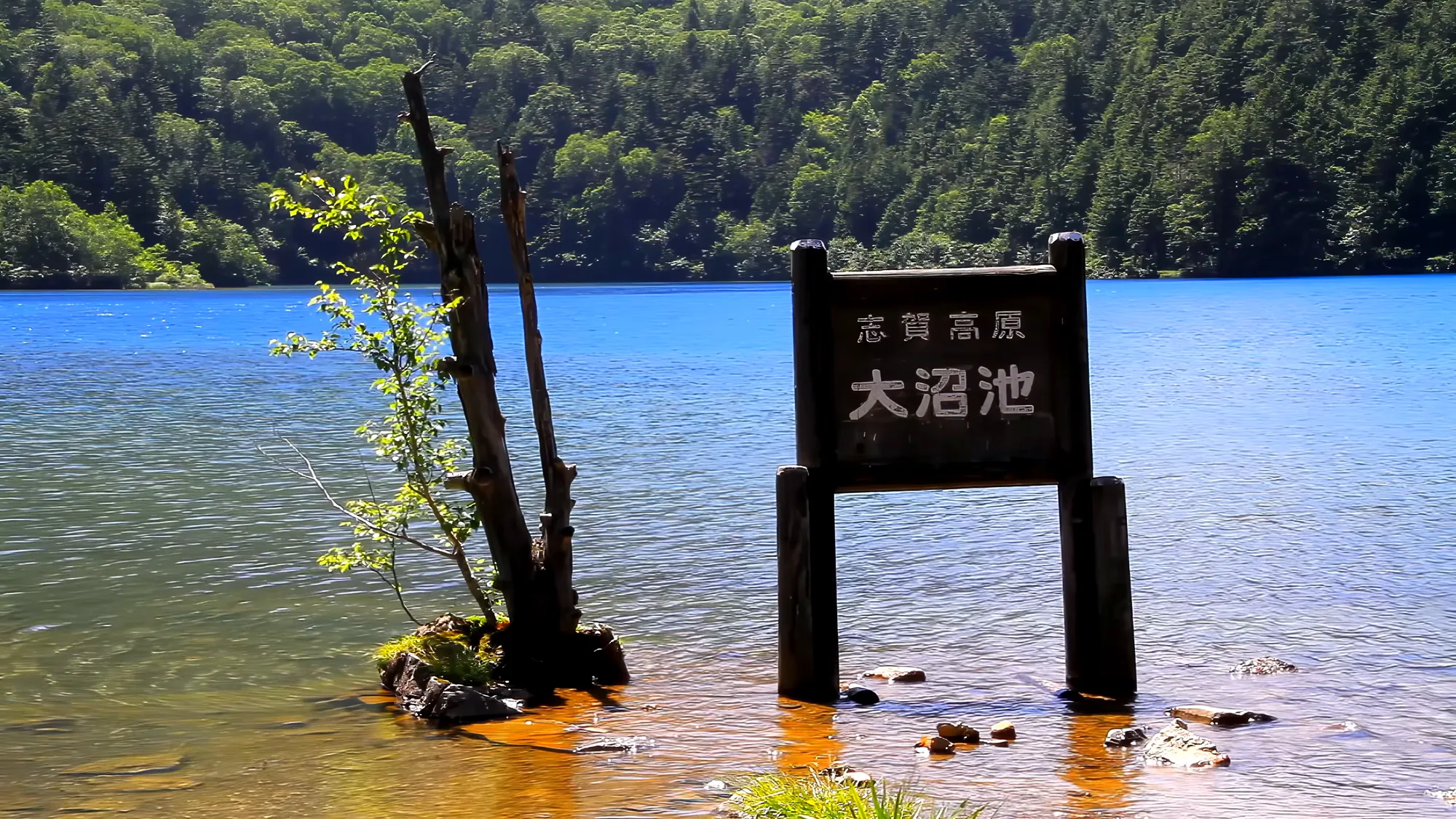
The shoreline at Onuma-ike, where the water goes from clear to blue in a step.
Seventy ponds, and what a headwater zone is
The defining number here is the water: seventy-odd ponds and marshes, in what the base calls a 水源地帯, a source zone.
Shiga Kōgen is volcanic country at the junction of Gunma, Niigata and Nagano. What produces seventy ponds in one highland is a combination of three things: heavy snow, a lot of flat ground at altitude, and ground that does not drain. Volcanic terrain dams itself. Lava flows and ash deposits block valleys and leave basins, and basins at this elevation fill with meltwater and then fail to empty.
What grows in them is the real attraction, and it is the same category of habitat as Otari’s Tsugaike moor and Achi’s skunk-cabbage ground: 湿原, high moor. Cold, waterlogged, acidic, nutrient-poor ground where dead plants do not fully rot, so the surface slowly builds into peat. These are among the slowest-forming and least repairable landscapes in Japan. A boardwalk across a moor exists because a single boot print in the wrong place takes decades to heal.
So the five roads going round the marshes and lakes is also a statement about construction. You will be on boardwalk, which is incidentally the single best surface there is for the one accessible road, and probably the reason it exists.
The peaks named are 志賀山 and 岩菅山, both of the two-thousand-meter class, 2,000 m (6,560 ft) and up. The trees are a clean subalpine set:
コメツガ (Tsuga diversifolia, northern Japanese hemlock), オオシラビソ (Abies mariesii, Maries’ fir) and クロベ (Thuja standishii, Japanese arborvitae) for conifers, and ミズナラ (Japanese oak) the single broadleaf. The notes field reads 亜高山針葉樹林.
That combination is the signature of the highest forest belt in Japan. Oshirabiso in particular is the tree of the subalpine zone on the snowy side of the country. It is what forms the dense dark stands at the top of Honshū’s mountains, and in winter it is the tree that becomes the famous snow monster shapes when rime ice loads it. Below it, mizunara marks where the subalpine gives way to the cool temperate broadleaf forest. A visitor walking between those two species is walking across a treeline.

The basin in August. Six weeks later all of this is brown.
All four seasonal fields are blank, which on a base whose attraction is high-moor flowering is the most consequential omission here.
A UNESCO Biosphere Reserve, and what it actually certifies
The base makes one claim that outranks the national park designation. Shiga Kōgen is certified as a ユネスコエコパーク, internationally recognized as a model area practicing the coexistence of nature and human society.
ユネスコエコパーク is Japan’s name for a Biosphere Reserve, and the distinction from a national park is worth drawing.
A national park protects a landscape. A Biosphere Reserve is designed around the premise that people live and work inside it. The model is zoned, with a strictly protected core, a buffer around it, and an outer transition area where farming, forestry, tourism and settlement are not merely tolerated but are the point. The thing being certified is not wilderness. It is a working relationship.
Which makes it the most appropriate designation in Japan’s certified forests for what forest therapy actually is. Japan’s certified healing forests are worked ground. Plantations, coppice, pilgrim roads, quarry tracks, charcoal kilns, logging railways, satoyama maintained by volunteers on a Sunday. Almost none of them is wilderness. Shiga Kōgen is the one that has an international certificate saying so.
And it sits beside an irony worth noticing. The same highland holds ski resorts, ninety inns, eight hot spring districts, a chairlift to 2,307 m (7,569 ft) and seventy fragile peat moors. That is coexistence as a practical problem rather than a slogan, and the reserve designation is an assertion that it is being managed rather than merely happening.
Eight hot springs, ninety inns, and no day-use building
The hot spring situation here is the largest of any certified base, and it comes with a catch.

Birch on the marsh edge, holding the last of it.
Eight districts are named: 発哺温泉, 熊の湯温泉, 木戸池温泉, 熊の湯ほたる温泉, 志賀山温泉, 高天ヶ原温泉, 幕岩温泉, 丸池・蓮池温泉.
And then: there is no dedicated day-use facility, but there are many places where you can take a day bath at an inn.
That is an important practical warning and almost no visitor would anticipate it. Eight hot spring districts, and nowhere built for walk-in bathing. You are asking an inn to let you use its bath, which in Japan is normal, is usually fine, and is never guaranteed. Hours are short, they can refuse when busy, and nothing is published.
Ninety lodgings of all sizes, with the tourist association offering to match one to your budget and purpose on 0269-34-2404.
Ninety inns and eight springs across one highland is the infrastructure of a major ski region, which is what this is. The forest therapy base is using a resort’s bones, in the same way Achi’s base uses a ropeway’s, and the running pattern applies: what the operator already owns determines what the visitor gets. Here that means beds and baths in abundance, and no road data whatsoever.
The hub is the 志賀高原自然保護センター, inside 志賀高原総合会館98 at Hasuike, with three-dimensional models and panels explaining the forests, marshes and the origins of the landscape, and staff who will brief you on trekking routes and what is flowering. 0269-34-2133, open every day.
And the snow monkeys are on the list
One of the facilities listed beside this certified forest is 地獄谷野猿公苑, Jigokudani Monkey Park, where around two hundred Japanese macaques are fed and you can watch them sitting contentedly in a hot spring made for monkeys.
It is the same town. 山ノ内町 holds both the certified forest therapy base and the most internationally famous wild-animal site in Japan, and the Society’s page treats the second as a day trip from the first.

Two planks wide, three kilometers of it, and nobody coming the other way.
For a reader, that is the most useful planning fact available. You can walk a certified therapy road on a high moor in the morning and be watching macaques in a hot spring in the afternoon, in one municipality, without moving your luggage. Very few places in Japan can offer two things of that quality that close together, and nothing in the forest therapy literature mentions it.
The other listed attraction is the 横手山 lift: a スカイレーター, a moving walkway on a slope, and then a chairlift, up to 2,307 m (7,569 ft), with a 360-degree panorama from the top. 0269-34-2600.
A moving walkway as the first stage of getting up a mountain is worth noting beside Achi, which uses a ropeway to make a forest reachable. Shiga Kōgen has a conveyor belt and a chairlift to 2,307 m (7,569 ft). Whether either is usable by a wheelchair is unpublished in both cases, but the mechanism keeps appearing, and in a country of steep mountains and an aging population it is going to matter more than any amount of path-widening.
And the souvenir, which is wonderfully specific: サバタケ, a bamboo-shoot soup made with 根曲がり竹, the bent-root dwarf bamboo of these slopes, and canned mackerel. There is said to be nobody in Yamanouchi who does not know it, and it is a limited-quantity product. 0269-31-1008.
One town, two world-famous things, and nobody has noticed
It is worth staying with Yamanouchi for a moment, because the municipality is doing something no other town manages, and no source has connected it.
山ノ内町 holds a certified forest therapy base and Jigokudani Monkey Park. The first is a UNESCO Biosphere Reserve at the center of a national park, with five therapy roads, seventy ponds, eight hot spring districts and ninety inns. The second is, by a wide margin, the most internationally recognizable wild-animal site in Japan: the macaques in the hot spring, which appear on magazine covers and nature documentaries and in the travel plans of a very large number of people who could not name another Japanese town.
They are in the same town, and the Society’s page lists the second as a facility of the first.

The valley turns from the top down, over about ten days.
What makes that worth stating is the asymmetry. An enormous number of foreign visitors come to Yamanouchi every winter for the monkeys. Essentially none of them know they are standing in a certified forest therapy base, because nothing in English says so, and Shiga Kōgen’s own page publishes no road names, no seasons and no access information even in Japanese.
So here is the most valuable sentence available to a reader: if you are going to see the snow monkeys, you are already going to a certified forest therapy base, and you should give it a second day.
The two also sit at opposite ends of the year, which makes them complements rather than competitors. The monkeys are at their most photographed in deep winter, in snow, which is also when the high moors are buried and the therapy roads are under a ski resort. The moors flower in high summer, when the monkey park is quieter and the valley below is too hot to enjoy. A visitor could come twice to one town and have two completely different holidays, and no published source in either language suggests it.
The headwater, and what it is for
One more thing follows from 水源地帯, the word used for this whole highland, and it is the part that explains why anybody protected it.
A headwater zone is where rivers begin. Seventy ponds and marshes at 2,000 m (6,560 ft), holding snowmelt in peat and releasing it slowly, are the reason the rivers below run at all, and the valleys below Shiga Kōgen are rice country. The same relationship holds at Taruda in Niigata, where a beech forest’s stored snowmelt waters the paddies that grow Japan’s most expensive rice.
Here it is stated more plainly, because the base uses the technical term rather than implying it. 志賀高原 is not scenery that happens to have water in it. It is the water supply, and the forest is what holds it in place.
Which is also the cleanest possible justification for the Biosphere Reserve designation, and for the fact that you will be walking on boardwalk. A moor that takes centuries to form and supplies a valley’s water is not a surface you walk on directly. The planks are not a convenience. They are the protection, and the fact that they happen to be the best wheelchair surface in Japanese forestry is a genuine accident of conservation engineering.

Above 2,000 meters the trees stop and the ground goes yellow.
The five roads, and the bus that reaches them
The Society’s page names no road and gives no measurement. The town’s tourism association and visitor center publish all five, and they are the difference between knowing this base exists and being able to walk it.
Sunshine Trail and Mizunashi Pond (サンシャイントレール・水無池) is the forest therapy course proper: 3.9 km (2.4 mi), about an hour and a half, climbing 100 m (330 ft). If you walk one road here, walk that one.
The pond circuit (池めぐり) is the long day at 9.6 km (6.0 mi) and about three and a half hours, and it is the one that earns the seventy-ponds description. Seseragi (せせらぎ) is the short one, 1.8 km (1.1 mi) in about an hour. Okushiga Shirakaba Enro (奥志賀白樺苑路) runs 3.7 km (2.3 mi) in about an hour and twenty minutes, and the nature trail (自然探勝) 4.1 km (2.5 mi) in about two hours.
Guides work the season from early May to the end of October. The hub at Hasuike sits around 1,500 m (4,920 ft), and parking is free.
Getting here without a car is easier than the altitude suggests. The Nagaden express bus (急行志賀高原線) runs from Nagano to the Yama-no-Eki in 70 minutes for ¥2,500 (about $17), four departures a day, no reservation needed. In winter it takes 80 to 87 minutes and costs ¥3,000 (about $20).
And the detail that reorganizes a trip: the Snow Monkey Park is a scheduled stop on that same bus, 50 minutes out of Nagano for ¥2,000 (about $13). One bus, one morning at the monkeys, one afternoon on a therapy road at 1,500 m (4,920 ft), and no car.
What is not published
For a base with this much infrastructure around it, the forest itself is almost undocumented.
No road is named. No length, time, gradient or surface for any of the five, including the barrier-free one. All four seasonal fields blank, on a high-moor base whose attraction is flowering, which is the single most frustrating omission here. No elevation for the roads: the peaks are given, the paths are not. No base area. No therapy program. No price. No bentō field. No guide message. No fauna, on a page that separately lists two hundred macaques at a facility down the road. No access information: no station, no journey time, no fare. And no email address.

Sunset from the high road, which closes for the winter not long after this.
The operator is the 志賀高原ビジターセンター on 0269-34-2133, and the base runs its own site at visitor-center.shigakogen.gr.jp, which is where the road names are.
So the 可 for barrier-free rests on the one number, one road of five, and nothing else. That number is worth more than most 可 marks, because it is specific enough to start a useful conversation. But the road is not named, and the four questions therefore have an extra one in front of them: which of the five is it. Then the surfaced width, a step at the trailhead, the surface from the parking lot, and the accessible toilet. All to 0269-34-2133.
Go in late July, and ask which road
The timing is forced by the moors, and the base does not say so.
High moors in Japan flower in a narrow window after the snow leaves, and at Shiga Kōgen’s altitude that is high summer rather than spring. Late July into early August is when a Japanese subalpine marsh is at its best, which is also, not coincidentally, the only time of year when the valleys below are unbearable and this highland is the obvious place to be.
Walk one of the lake-and-marsh roads on boardwalk. Then take the moving walkway and the chairlift to 2,307 m (7,569 ft) for the panorama, because it is there and it is absurd and it costs very little. Get a day bath at one of the inns, having phoned first, because there is no building for it. Eat the mackerel-and-bamboo soup.
And give a day to the monkeys, who are in the same town and who have been getting into hot water on this mountain for longer than forest therapy has had a name.
Before any of it, call and ask which of the five roads is the barrier-free one. Shiga Kōgen and Otari have both answered the hard half of that question in public. Neither has finished the sentence.
Nearby and alike

Nagano · Certified 2007
Otari
Primeval beech under a mountain on Japan’s hundred-famous list, a hundred-hectare high moor at 1,900 meters, ten hot springs, and the salt road where an enemy was kept alive on purpose.

Nagano · Certified 2007
Kijimadaira / Kayanodaira
Primeval beech at 1,350 meters with a moor that vanishes under day lilies in mid-July. One of four certified bases in Japan that say no to every question they are asked.

Nagano · Certified 2010
Achi / Heavens Sonohara
A single 2.3-kilometer loop in forest the operator calls primeval, at the top of a cable car — the only certified base in Japan using a lift to solve the mountain.
Verified by The Japan Onsen Society
Sources
森林セラピー「長野県 うるわしの森 志賀高原」— https://fo-society.jp/facility/nagano-shigakogen/ (うるわしの森 志賀高原; 雲上のセラピーロード「みどり響く 湖沼めぐり」; 山ノ内町; 認定 2008年4月; ⭐ ロード数 5(うちバリアフリーロード1), no road named or measured; all four service fields 可; 長野県の北東部, 群馬・新潟・長野にまたがる上信越高原国立公園の中央, 志賀山・岩菅山など2000m級の山々, 大小70余りの池沼や湿原が広がる水源地帯; 5本のセラピーロードはその特色を生かし、広域にまたがり、原生林の森や湿原、湖沼などを巡る変化に富むコース; ⭐ 「自然と人間社会の共生」を実践するモデル地域として、国際的に認定されるユネスコエコパークの認定; conifers コメツガ・オオシラビソ・クロベ, broadleaf ミズナラ, notes 亜高山針葉樹林; all four seasonal fields ー; 志賀高原自然保護センター(志賀高原総合会館98 2階)— 立体模型やパネル, トレッキング・散策情報, 動物や花の開花情報, 山ノ内町大字平穏7148(蓮池), 0269-34-2133, 定休無休; ⭐ 温泉 — 発哺・熊の湯・木戸池・熊の湯ほたる・志賀山・高天ヶ原・幕岩・丸池蓮池, 日帰り専用施設はないが、宿で日帰り入浴ができるところも多い; 90軒もの宿泊施設, 0269-34-2404 志賀高原観光協会; サバタケ — 根曲がり竹とさば缶のたけのこ汁, 町民なら知らない人がいない, 数量限定, 0269-31-1008; ⭐⭐ 地獄谷野猿公苑 — ニホンザル約200匹が餌付けされ、サル専用の露天風呂に気持ちよさそうにお湯に入る様子が見られます; 横手山 — スカイレーター(動く歩道)とリフトを乗り継いで、標高2,307mの山頂へ, 360°の大パノラマ, 0269-34-2600; contact 志賀高原ビジターセンター, 0269-34-2133, email field EMPTY; official site https://visitor-center.shigakogen.gr.jp/)
森林セラピーソサエティ「森林セラピー基地 検索・一覧」— https://fo-society.jp/base-road_list/ (Shiga Kōgen = No. 29, 長野県, all four columns ◯)
森林セラピー「長野県 森林セラピー基地小谷」— https://fo-society.jp/facility/nagano-otari/ (for the comparison: 4(うちバリアフリーロード:1))
Verified: 2026-10-05