
Narrow path running between two walls of thick green moss and fern in the gorge at Nichinan, Miyazaki
Step-free
Partly step-free
One of two roads; Hachinosu path is flat
The main road
Inohae gorge
猪八重渓谷 · 3 km (1.9 mi) · about 90 min
Open
Year-round
Eight hundred maples in autumn
Nearest station
Kitagō
JR Nichinan Line, then 12–20 min by car
The record
What you need to go
Open season
Open year round and good in every season. Ten thousand cherries at Hanadate park in spring, eight hundred maples along the Hachinosu embankment in autumn
Getting there
Kitagō (北郷) on the JR Nichinan Line, about 60 minutes from Miyazaki, then 12 to 20 minutes by car or taxi to the gorge
Fees
A 1.5 km (0.9 mi) guided loop over 2.5 hours is ¥11,500 (about $77) each for two or ¥7,500 (about $50) each for five. A 6 km (3.7 mi) loop over 3.5 hours falls to ¥2,300 (about $15) each for ten
Onsen
Kitagō Onsen (北郷温泉), a sodium bicarbonate spring at 51 °C (124 °F) drawn from 800 m (2,625 ft) down, found in 1975
The walk
Main trail
The moss road up Inohae gorge (猪八重渓谷), about 3 km (1.9 mi) and 90 minutes, over seven numbered bridges to a five-tiered fall
All trails
2 trails, one of them barrier-free, neither named. The moss road runs 2.6 to 3 km (1.6 to 1.9 mi) one way
The step-free road
One of the two roads is barrier-free, but nobody says which. The Hachinosu embankment path is flat, rising 18.5 m (61 ft). No phone signal in the gorge
The forest
Forest type
Obi cedar country with a gorge of evergreen broadleaf forest inside it, from about 200 to 350 m (656 to 1,148 ft), holding seven waterfalls
What grows
Evergreen oak · Chinquapin · Tabunoki · Ichiigashi, glossy-leaved broadleaf forest, with 177 mosses and 116 liverworts counted
What lives
34 bird species counted, among them mountain hawk-eagle, brown hawk-owl and ruddy kingfisher. Giant flying squirrel, marten and badger. Kajika frogs in the stream
Certified since
2008
All figures updated 5 October 2026
The forest, before the facts
In a gorge in the far south of Miyazaki, along a stream that falls in seven waterfalls, there are about three hundred kinds of moss. The people who guide walks there count about twenty of them as endangered. The path through the gorge has a nickname, the moss road, and it runs along the clear stream for about three kilometers (1.9 miles) to 五重の滝, a five-tiered fall at the heart of the group.
The forest around it is evergreen broadleaf, glossy-leaved woodland of evergreen oaks and laurels. Thirty-four species of bird have been counted in the protected forest around the gorge, among them the mountain hawk-eagle and the ruddy kingfisher. From somewhere along the stream, the guides say, you hear kajika frogs.
And then there are the rails. Old tramway track still lies in the gorge, along with the remains of a water tank, a weir and charcoal kilns, left by the people who worked here into the postwar years. The tramway carried cedar out of the valley.
Five reasons to come
About three hundred kinds of moss in one gorge, some twenty of them endangered.
Seven waterfalls along one stream, with a five-tiered fall at their heart.
An evergreen forest where the national survey counts thirty-four bird species.
A hot spring at 51 °C (124 °F), drawn from 800 meters (2,625 feet) down.
Ten thousand cherry trees on a hilltop park at 489 meters (1,604 feet).
A cedar town with a broadleaf gorge
The base goes by a long name: the healing village, Cherry Town Kitagō (癒しの郷・チェリータウン北郷). Its tagline is surrounded by Obi cedar and cherry blossom, a town where you meet the landscape you were looking for. It was certified in 2008.
It sits in the southeast of Miyazaki Prefecture, warm through the year, with mountain forests behind it and the Nichinan Coast Quasi-National Park in front, more than 100 kilometers (62 miles) of coastline. The city has covered 536.12 square kilometers (207 square miles) since a merger in 2009.
The name to know is Obi cedar (飫肥杉). This is one of the districts that grows it. That is the contrast the moss road walks through: cedar country, with a gorge of evergreen broadleaf forest inside it.

Goju-no-taki, the fifth and last fall, two and a half hours up the gorge.
In the gorge itself there are no conifers listed at all. What grows there is evergreen oak and chinquapin: glossy-leaved broadleaf forest.
The moss road
The gorge is Inohae (猪八重渓谷). The national forest around its waterfalls is the Inohae falls scenic forest (猪八重の滝風景林), and it is on Japan’s national list of recommended beautiful forests.
The path along the stream runs about 3 kilometers (1.9 miles) one way, about ninety minutes to the five-tiered fall, partly on woodchip. Seven waterfalls stand in the valley, among them 岩坪の滝. The trees are chinquapin, laurel and evergreen oak; イワタバコ grows on the wet rock; and one crossing is called 涼風橋, the cool-breeze bridge.
The guides describe the walk in terms of sound and moss: kajika frogs calling in the distance, wild birds overhead, and about three hundred kinds of bryophyte in the gorge, some twenty of them endangered.
A survey of the protected forest puts it at much the same: 177 mosses, 116 liverworts and three hornworts, 296 in all.
The measurements
The scenic forest covers 71.80 hectares (177 acres), at elevations from about 200 to 350 meters (656 to 1,148 feet), mostly between 200 and 250 meters (656 and 820 feet). That is the elevation band of the moss road.
The history runs in three lines. In the Edo period this area was known for large-diameter cedar used to build ships. After the war a small hydroelectric plant went up in the gorge, to help settle and develop the area. And the trolley tracks that carried timber ran until around 1965.
At the trailhead there is free parking for seventy cars, toilets, drinking water, vending machines and a free footbath. The forest is good in every season.
One waterfall, 流合の滝, is read two ways: Hakeai and Hakiai.
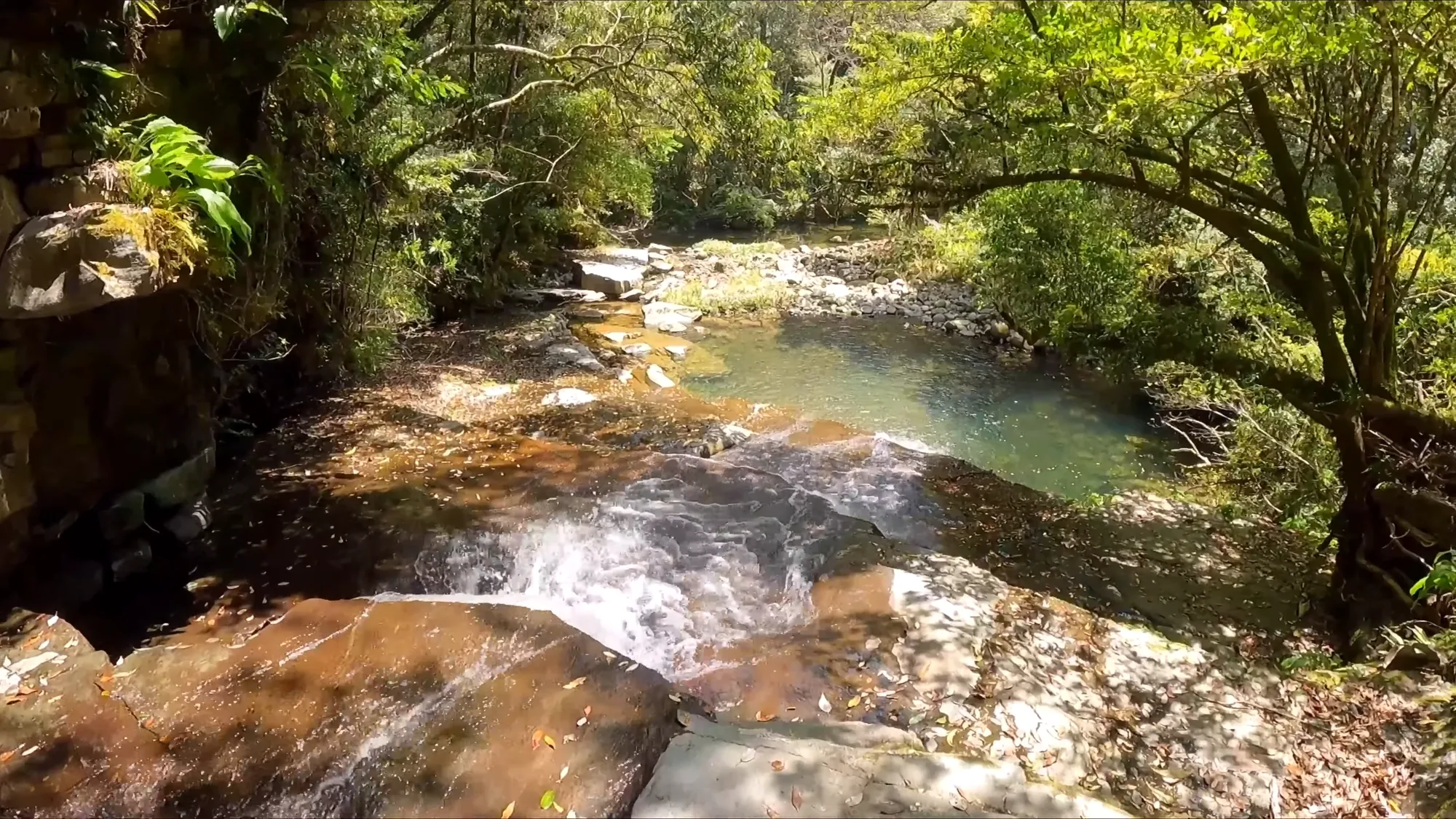
The stream is the trail for about half of it.
Seven bridges and a shipbuilders’ cedar
The walk crosses the stream again and again on numbered bridges, one through seven. Along the way, before the five-tiered fall, come Hakiai falls (流合の滝), Iwatsubo falls (岩つぼの滝), Kame falls (瓶の滝), and a rock called the clam rock (はまぐり岩).
The rails explain themselves once you know what they carried: Obi cedar, valued as timber for building ships. Partway along there is a learning forest, the site of the old power plant, and a giant evergreen oak (イチイガシ), the first tree named among the gorge’s own.
Count on about 2.6 kilometers (1.6 miles), an hour and a half at an easy pace. And know one thing before you set off: neither mobile phones nor satellite phones work in the gorge. There are toilets at the parking area and at the five-tiered fall.
Three hundred kinds of moss, in one gorge. Kneel down and look at it properly before you walk on.
What lives in the protected forest
Around the gorge is a larger protected area, and its wildlife has been surveyed in unusual detail. It is protected for its whole biological community, designated on 5 September 2018, and it covers 480.79 hectares (1,188 acres) between about 250 and 700 meters (820 and 2,297 feet).
Eight species of mammal were counted. Among those named are the Japanese giant flying squirrel, the Japanese marten, the Japanese badger, the Japanese hare, the raccoon dog, the wild boar and a small tube-nosed bat.
Thirty-four species of bird were counted, among them the mountain hawk-eagle, the brown hawk-owl, the ruddy kingfisher, the Japanese paradise flycatcher, the Japanese night heron, a copper pheasant and ソウシチョウ.
Ten species of reptile and amphibian were counted, among them several snakes, and sixty-three insects, including the giant dragonfly and the butterflies アオスジアゲハ and アサギマダラ. There are 124 species of vascular plant, with イチイガシ, コジイ, スダジイ, タブノキ, ハナガガシ and ウラジロガシ among the main trees.
The forest carries other protections too: watershed and health protection forest, the Wanitsuka prefectural natural park, and a wildlife protection area. None of this tells you what you will see on a given morning. It tells you what has been counted.
Two roads, and which is which
The base has two roads, one of them barrier-free. Neither is named.

Warm-temperate evergreen forest, which keeps the gorge dark all year.
The operator, the local forest therapy council run by the NPO ごんはる, builds its guided walks around the Inohae gorge. A second location, the Hachinosu gorge (蜂之巣渓谷), is walked as forest therapy too: a 1.6-kilometer (1.0-mile) path one way along the embankment of the Hirowatari River (広渡川), rising only 18.5 meters (61 feet), part of a 3.5-kilometer (2.2-mile) Nordic-walking course. Eight hundred Japanese maples were planted along it in 2005, and there is free parking for seventy cars at 蜂之巣公園.
No one has said that the Hachinosu path is the barrier-free road. It is flat, and it follows an embankment, and those are reasons to ask, not an answer. Ask the council.
The guided walks, and what they cost
The council runs two plans at the Inohae gorge, priced per person, falling as the group grows. The relaxing plan (森でくつろぎプラン) is a 1.5-kilometer (0.9-mile) loop over about two and a half hours. It costs ¥11,500 (about $77) each for two people, and ¥7,500 (about $50) each for five.
The refreshing walk (森歩きでリフレッシュプラン) is a 6-kilometer (3.7-mile) loop over about three and a half hours. It costs ¥11,200 (about $75) each for two, ¥4,500 (about $30) each for five, and ¥2,300 (about $15) each for ten. What is included, and whether tax is, is not published, so ask.
The council also lists other experiences: nature games, making moss balls, inoculating logs with shiitake spawn, and strawberry picking.
They are steep for two, and they fall steeply with numbers. This is a base to visit as a group.
Three numbers for one path
The length of the moss road comes three ways. About 3 kilometers (1.9 miles) one way to the five-tiered fall, in about ninety minutes. Or 2.6 kilometers (1.6 miles) from the entrance to the upper falls, also about ninety minutes at a leisurely pace. The council’s two guided plans are loops of 1.5 and 6 kilometers (0.9 and 3.7 miles).
These are not necessarily in conflict. They are three different walks on the same ground. But if you want to know how far it is to the five-tiered fall, you will find two answers.
Two practical warnings: there are toilets at the parking area and at the upper falls, and there is no mobile phone reception in the gorge.

The path crosses and recrosses, and the steps are wet from October to June.
The bath, the cherries, and the shochu
The hot spring is Kitagō onsen (北郷温泉). It rises from 800 meters (2,625 feet) underground at 51 °C (124 °F), a sodium bicarbonate spring rich in sodium ions, known locally as the bath for beautiful skin. It was found in 1975 in the 大藤 district.
There are several places to bathe and stay, among them ホテルジェイズ日南リゾート, サンチェリー北郷, 音色香の季 合歓のはな, べっぴんの湯, and the cottages at 蜂之巣公園. Higher up, at 290 meters (951 feet), 日南北郷リゾート puts a hotel, golf and a hot spring together.
The town’s cherry name comes from Hanadate park (花立公園). It holds about ten thousand cherry trees, Somei-Yoshino and mountain cherries, across 18 hectares (44 acres), at 489 meters (1,604 feet).
And there is a shochu distillery. At the Shochu Dōjō (焼酎道場) you can watch the distilling, and try it yourself by reservation. Entry is free, nine to four, closed only at New Year.
Where to stay, and what to buy
日南北郷リゾート, at 290 meters (951 feet), combines a hotel, golf and a hot spring, with check-in at three in the afternoon and check-out at ten, on 0987-55-3333.
蜂之巣公園, Hachinosu park, has lit tennis courts, a children’s pool, a multipurpose ground, a forest bathing path, and hot spring cottages with the same check-in and check-out times, on 0987-55-3828. If the flat embankment walk along the Hirowatari River is the one you want, this is where it starts.
For food, two farm stands, 大戸野即売所 and 大藤即売所, sell local vegetables, dumplings, tea, miso and pickles, with simple meals including udon and soba. That matters here, because nobody sells a therapy bentō, and the stands are the obvious place for lunch.
The Shochu Dōjō is on 0987-55-4134. Visiting is free.
When to come
No seasonal calendar is published for this base, and there is no therapy bentō.

The moss holds the water and lets it go slowly, which is most of what moss does.
So take the cue from what has been planted. The ten thousand cherries at Hanadate say spring. The eight hundred maples along the Hachinosu embankment say autumn. The gorge itself is good in every season.
On wheels
The base can accommodate wheelchairs and strollers, and one of its two roads is barrier-free. That is a better answer than most places give, and it still does not say which road, or what a wheelchair will meet on it.
Ask the council four things. How wide is the surfaced path on the barrier-free road, in centimeters?
Is there a step where it begins? What is the surface between the parking lot and the start? And is there an accessible toilet at the parking area?
Getting there
There are two ways in. By train, the JR Nichinan Line runs from Miyazaki station to 北郷 (Kitagō) station in about sixty minutes. By car, it is about forty minutes from Miyazaki Airport to Kitagō, and about twelve minutes from Kitagō station to the Inohae gorge.
A taxi from Kitagō station to the gorge takes about twenty minutes; it is about 5 kilometers (3.1 miles) from the Nichinan-Gōnohara exit of the expressway. Hachinosu park is about fifteen minutes by car from the gorge, the Kitagō onsen about twenty, and Obi castle (飫肥城) about thirty. From Miyazaki city it is about 65 kilometers (40 miles), an hour and a half; from the Tano exit of the Miyazaki Expressway, about 30 kilometers (19 miles), forty-five minutes.
The contact for the walks is the council, on 0987-55-2700. The town’s regional promotion center is on 0987-55-2112.
The shape of a day
Take the JR Nichinan Line from Miyazaki, or fly in and drive. Walk the moss road in the morning with a guide, slowly, with a group if you can gather one. Listen for the frogs. Look up for the kingfisher, and do not expect it.
Buy lunch at one of the farm stands, since nobody here sells a therapy bentō. In the afternoon, if it is spring, go up to the ten thousand cherries. Then go down into water at 51 °C (124 °F) from 800 meters (2,625 feet) below, in a town that grows cedar for a living and has a gorge of evergreen forest where three hundred kinds of moss still grow.
Nearby and alike

Kagoshima · Certified 2007
Kirishima
Japan’s first national park, stone-paved forest with two-hundred-year trees and wild deer, columnar basalt beside the shrine of the gods’ descent — and a guided walk, once a month, for eight hundred yen.

Miyazaki · Certified 2006
Hinokage
One of Japan’s first six forest therapy bases, laid along an old railway, a logging trolley line and 1850s stone terraces.

Ōita · Certified 2012
Ōita
Ten certified roads within an hour of Ōita, from a flat museum loop to a five-star ridge, with guides at ¥3,000 a group.

Forest and Onsen
Two old Japanese ways of resting the body meet in the Kiso valley. Cypress air, hot water, and what is known.

Choosing a Base
Eight forests, from Kusatsu to Yakushima. Which fits your days, your season and the onsen waiting after.

The Walk
A measured forest walk is about thirty minutes and no destination. Here it is, sense by sense, step by step.
Verified by The Japan Onsen Society
Sources
森林セラピーソサエティ「宮崎県 日南市 癒しの郷・チェリータウン北郷」— https://fo-society.jp/facility/miyazaki-nichinan/ (認定 2008年; all four access fields 可; 2 roads, 1 barrier-free, unnamed; tree fields カシ・シイ, 照葉樹林; seasons blank; no bentō field; 北郷温泉 51 ℃, 800 m, sodium bicarbonate, 美人の湯, 昭和50年 大藤; 花立公園 ~10,000 cherries, 18 ha, 489 m; 日南北郷リゾート 290 m; 蜂之巣公園; 即売所; 焼酎道場; 536.12 km²; 日南海岸国定公園 100+ km)
日南市北郷町森林セラピー協議会(NPO法人ごんはる)— https://gonharu.info/foresttherapy/index.html (two plans, loops, times, per-person prices; 約300種(内約20種が絶滅危惧種); カジカガエル and 野鳥; other experiences; access; lodging list; contact)
林野庁九州森林管理局「猪八重照葉樹林生物群集保護林」— https://www.rinya.maff.go.jp/kyusyu/keikaku/hogorin/shinrin_seibutsu/inohaesyouyouzyurinn.html (480.79 ha; 250–700 m; designated 5 Sept 2018; trees; 124 vascular; 177 mosses, 116 liverworts, 3 hornworts; 8 mammals, 34 birds, 10 reptiles/amphibians, 63 insects with names; protections)
林野庁九州森林管理局「猪八重の滝風景林」— https://www.rinya.maff.go.jp/kyusyu/kanri/rekumori/inohaenotaki-fukei.html (therapy base; 日本美しの森; 五重の滝, seven falls, 岩坪の滝; 3 km moss road, ~90 min; シイ・タブ・カシ; イワタバコ; 涼風橋; woodchip paths; tramway, water tank, weir, charcoal kilns; drive times to park, onsen, Obi castle)
林野庁「猪八重の滝風景林」(national) — https://www.rinya.maff.go.jp/j/kokuyu_rinya/kokumin_mori/katuyo/reku/rekumori/inohae.html (71.80 ha; 200–350 m; Edo-period shipbuilding cedar; postwar small hydro; trolley until ~1965; 70 free spaces; footbath; サツマニシキ; 流合(はけあい)の滝; 65 km / 1.5 h; Tano IC 30 km / 45 min; office 0987-25-1115)
たびんぐ「猪八重渓谷」「蜂之巣渓谷」— https://tabi-mag.jp/mz0198/ · https://tabi-mag.jp/mz0199/ [CITABLE, secondary] (bridges 1–7; 流合(はきあい), 岩つぼ, 瓶の滝, はまぐり岩; 弁甲材; learning forest; power plant ruins; イチイガシの巨木; 2.6 km / 90 min; no phone signal; toilets; Hachinosu 1.6 km, 18.5 m, 3.5 km Nordic course, 800 maples 2005, 70 spaces)
Verified: 2026-10-05