
Waterfall dropping into a dark pool surrounded by russet autumn foliage at Akiota, Hiroshima
Step-free
Unverified
Marked yes, no road described end to end
The main road
Ryūzu gorge road
龍頭峡セラピーロード · 3–3.7 km (1.9–2.3 mi)
Open
Year-round
Depends on snow in winter
The record
What you need to go
Open season
Open year round. Cherry in spring, paddleboards in summer, color at Sandankyo in autumn, snow trekking on Mount Osorakan in winter
Getting there
No station published. The gorge campground and forest hall sit about 8 minutes from the Togouchi interchange, so you need a car
Fees
A three-hour guided session is ¥8,000 (about $53) a person, with a second published figure of from ¥3,000 (about $20). Bentō ¥2,500 (about $17). A one-night package is ¥35,000 (about $233)
Onsen
Green Spa Tsutsuga (グリーンスパつつが), alkaline water in upper-floor baths looking out over the Chūgoku mountains, open to day visitors
The walk
Main trail
The Ryūzu gorge road (龍頭峡セラピーロード), 3 to 3.7 km (1.9 to 2.3 mi), gentlest of the five, climbing to two waterfalls
All trails
5 trails, 3 to 5.8 km (1.9 to 3.6 mi), with 45 to 199 m (148 to 653 ft) of height difference
The step-free road
Barrier-free is marked yes, but no road is described as passable on wheels end to end. The gorge road is paved in places and steepens near the falls
The forest
Forest type
A protected gorge of 31.40 ha (77.6 acres) dominated by hinoki with hemlock and cedar, under Hiroshima’s highest peak at 1,346 m (4,416 ft)
What grows
Cedar · Hinoki cypress · Beech · Horse chestnut · Oak, plus a ginkgo 48 m (157 ft) tall and reckoned at over 1,100 years
What lives
Fox, raccoon dog, hare, wild boar, deer and giant flying squirrel. Crested and common kingfishers work the stream, with amago trout in it
Certified since
2012
All figures updated 5 October 2026
The forest
In the Ryūzu gorge (龍頭峡) there is a stand of hinoki that Hiroshima Prefecture believes may be the last of its kind. Almost no primeval cedar or hinoki forest survives anywhere in the prefecture, and this may be the only place where a hinoki stand has been preserved. The prefecture made the gorge a nature conservation area in 1973.
The easiest of Akiota’s five forest therapy roads runs up that gorge to a pair of waterfalls — the gentlest of the five, paved in places, gently graded, steeper only near the falls. And you are not alone in there: fox, raccoon dog, hare, wild boar, deer, the giant flying squirrel, and two kingfishers working the stream.
Akiota is a town at the headwaters of the Ōta river. It has a gorge with the nation’s special scenic designation, the highest mountain in the prefecture, a grassy summit long used for mowing and grazing, and a ginkgo reckoned at more than eleven hundred years old. The forest therapy base takes in nearly all of it.
Five reasons to come
Five roads, from a paved gorge walk to Hiroshima’s highest mountain.
A hinoki stand the prefecture says may be its last preserved one.
The Sandankyo gorge, a national special scenic site, with a ferry crossing.
A grassy summit long used for mowing and grazing, with a 360-degree view.
A lunch that always contains beans, named for the local word for healthy.
A town at the source
Akiota sits in the northwest of Hiroshima Prefecture, in the headwaters of the Ōta river system, with Mount Osorakan (恐羅漢山) and the Sandankyo gorge (三段峡) inside the Nishi-Chūgoku Sanchi quasi-national park. It is rich in both nature and historical heritage, with lodgings and roadside stations built for the visitors who come in every season.
It was certified in April 2012, the first place in Hiroshima Prefecture to be certified for forest therapy.
Five roads
There are five roads: the Ryūzu gorge road (龍頭峡セラピーロード); the Mount Shinnyū road (深入山セラピーロード); two roads in the Sandankyo gorge, Kurobuchi (黒淵) and Sarutobi (猿飛); and the Mount Osorakan road (恐羅漢セラピーロード).
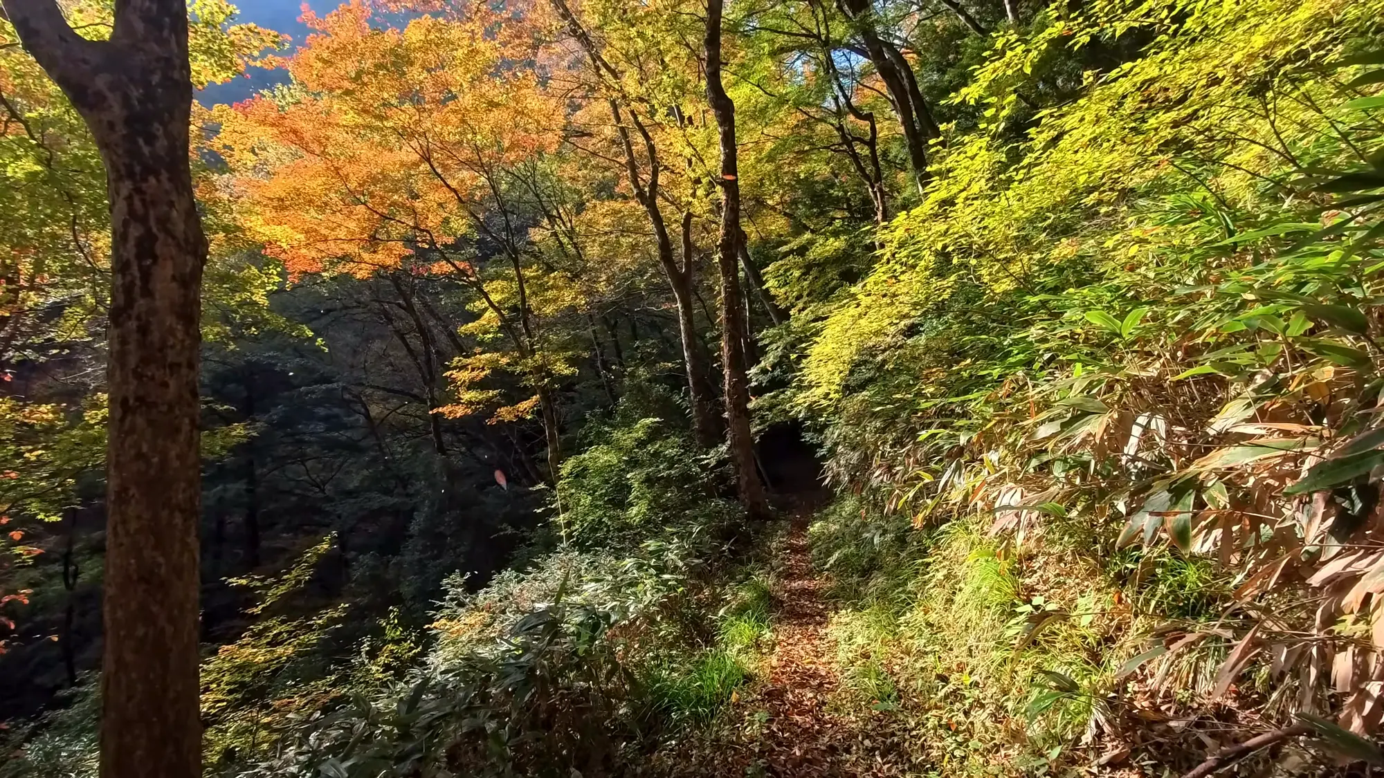
The gorge path in the first week of November, with the canopy still holding.
The Forestry Agency measures them like this.
Ryūzu gorge: 3 kilometers (1.9 miles), 155 meters (509 feet) of height difference.
Mount Shinnyū: 3.2 kilometers (2.0 miles), 165 meters (541 feet).
Kurobuchi: 5.8 kilometers (3.6 miles), 92 meters (302 feet).
Sarutobi: 3.2 kilometers (2.0 miles), 45 meters (148 feet).
Mount Osorakan: 3.7 kilometers (2.3 miles), 199 meters (653 feet).
The agency also estimates the calories, from about 546 for Sarutobi to about 989 for Kurobuchi. They are estimates, not measurements.
Two lengths for one gorge
The Ryūzu gorge road is given as 3.7 kilometers (2.3 mi) round trip in one place and 3 kilometers (1.9 mi) in another, and nobody explains the difference. Expect somewhere between the two.
The figures agree on Mount Shinnyū, 3.2 kilometers (2.0 mi), and on Mount Osorakan, 3.7 kilometers (2.3 mi). Kurobuchi is 5.8 kilometers (3.6 mi) round trip if you skip the ferry.
The gorge with the old hinoki
The Ryūzu gorge is the one to start with. It is the easiest of the five roads, one of a hundred selected hidden gorges of Japan, paved in places and gently graded. It steepens near the two-stage waterfall and the waterfall you can walk behind, but not for long, and the falls make natural places to stop.

For most of its sixteen kilometers the path is a ledge cut into the gorge wall.
Hiroshima Prefecture made the gorge a nature conservation area on 25 October 1973. The protected ground runs to 31.40 hectares (77.6 acres), a fine natural forest dominated by hinoki, with hemlock and cedar.
The larger claim is the prefecture’s own. Primeval cedar and hinoki forest is almost gone from Hiroshima, and this stand may be the only one left preserved.
What lives in the gorge
The prefecture’s inventory of the conservation area is unusually specific. The mammals are fox, raccoon dog, hare, wild boar, deer, and the giant flying squirrel.
Among the birds there are tits and thrushes, and two kingfishers: the crested kingfisher and the common kingfisher. In the stream there are amago trout and aburahaya minnow, and toads on the banks.
The stream insects are named too: clubtail dragonflies; mukashitombo, a relict dragonfly; mayflies; and net-winged midges. At the gorge’s campground what you mostly hear is the river and birdsong. The list covers the whole conservation area rather than the road itself, so read it as what lives in the gorge, not a checklist for one afternoon.
The grassy mountain
The Mount Shinnyū road is the other one for beginners: a grassland mountain with little height difference, well suited to a stroll, with wooden bridges over small streams and rest shelters along the way. Hot springs, lodging and a campground sit next to it.
The mountain stands at 1,153 meters (3,783 ft) and is known for its broad, pleasant grassland. That grass has long been cut for fodder and grazed.
Which makes Shinnyū a quiet example of a certified landscape laid over older work. The open summit is not untouched meadow. It is grassland people have put to use for a very long time.
The road can be extended to the summit, where the view is a full 360 degrees, on paths with lookouts and shelters that suit a beginning climber.

Sandankyo, which the river has been cutting for longer than anything standing beside it.
The mountain that is the highest
The Mount Osorakan road starts at the foot of the highest peak in Hiroshima Prefecture, 1,346 meters (4,416 ft).
The road is relatively gentle from the entrance up to the pass called Natsuyaki-no-kibire (夏焼のキビレ), and steep mountain climbing beyond it, for intermediate climbers. In winter you can go snow trekking, and in early May daffodils come up across the ski slopes.
The ski area, Osorakan Snow Park (恐羅漢スノーパーク), has a longest run of 2,500 meters (8,202 ft) and a vertical drop of 500 meters (1,640 ft), with a campground in summer.
Sandankyo
The Kurobuchi (黒淵) course, with a boat crossing, runs through the Sandankyo gorge — a national special place of scenic beauty, and one of only six gorges in Japan to hold that designation. Its length is given variously as thirteen kilometers (8.1 mi) and sixteen (9.9 mi); the walking course is 5.8 kilometers (3.6 mi) round trip if you skip the ferry.
About one-sixth of Japan’s 1,800-odd kinds of moss grow in the gorge. The boats run to the Kurobuchi pool and the Sarutobi rock, and from the water you look up at the cliffs. Credit for making the gorge known, and for the early work of preserving it, goes to the photographer Kuma Nanpō (1876–1943).
On wheels
Akiota answers yes on barrier-free access, and the roads themselves complicate that answer without contradicting it.
The Ryūzu gorge road is paved in places, but it steepens near both waterfalls. The Mount Shinnyū road has little height difference, but it crosses streams on wooden bridges. The Mount Osorakan road becomes a climb. No road here is described as passable on wheels from end to end.
So ask the operator four things, about the Ryūzu gorge road first. How wide is the paved section, in centimeters? Is there a step at the trailhead?
What is the surface between the parking area and the start? And is there an accessible toilet at the gorge’s campground or forest hall?

The water slows where the gorge widens, and goes green.
The price, two ways
Forest therapy here is ¥8,000 (about $53) a person, for about three hours. A stand-up paddleboard session costs the same ¥8,000 for about two and a half hours, and a one-night, two-day package runs ¥35,000 (about $233) a person, lodging included, travel not. Groups run from two to nine, or two to ten.
A second figure is also in circulation for a guided session: from ¥3,000 (about $20), for two or more, booked a week ahead. The ¥8,000 figure is the more recent of the two. Ask which one applies before you book.
A guided session runs through stretching and abdominal breathing, a mountain walk, a sleep in a hammock, and time spent watching birds and wild plants, and it finishes at the waterfalls and streams — which the operator describes as a negative-ion bath. That last part is their claim, not ours. Nobody has produced a measurement for it.
The guide’s promise
The message from the guides is short. They value facing each guest one by one and making a connection, they say, and they will take you on a mountain walk unlike your usual one.
The base takes corporate training groups, visitors from abroad, and children. The occupational health seminar described below is one example of the corporate side; the stretching-and-breathing session above is the clearest account of what an ordinary day with a guide contains.
The lunch
The lunch is worth ordering by name. It is the Satoyama Genki (Mame) bentō, 里山元気(まめ)な弁当, and it costs ¥2,500 (about $17) including tax.
In the Akiota dialect mame means healthy, and the lunch is built to make you mame after a day in the forest. It is made with rice grown in the town and seasonal food, always includes beans, uses more than twenty ingredients and cane sugar, and aims to taste of the season.
The pun is the point. Mame is also the word for beans.
Who runs it, and what that means
The operator is Chiiki Shōsha AkiŌta (一般社団法人地域商社あきおおた), a general incorporated association that calls itself a regional trading company.

Down on the floor the light arrives late and leaves early.
That is a distinct kind of operator: not a town office, not a tourism association, but an organization set up to sell a town’s products and experiences. It shows in the product. Forest therapy is one line among others, priced alongside paddleboarding and a two-day package with lodging, and the bentō is branded.
The implication cuts both ways. A trading company has a reason to keep the base selling and to package it well. It also means the base is one product in a portfolio, and its future depends on how it sells against the others.
Training doctors in the gorge
The base has also been used to train doctors. Sangyō Hoken 21, an occupational health journal, reported in July 2022 on a three-part seminar run by the Hiroshima occupational health support center with the trading company.
The first session covered applying forest therapy to workplace mental health, and the second covered self-care and exercise therapy. The third was field training in the Ryūzu gorge, and it carried 2.5 practical credits toward the continuing training of occupational physicians.
Participants are reported to have experienced the physiological effects. No measurement, no participant count and no result came out of it. What is worth knowing is simpler: occupational physicians in Hiroshima are sent up this gorge as part of their professional training.
Two trees the prefecture protects
Three trees are singled out here, and two of them are worth the detour.
The great ginkgo of Tsutsuga (筒賀の大銀杏) stands 48 meters (157 ft) tall and 8.2 meters (27 ft) around, a prefectural natural monument, reckoned at more than 1,100 years old.
The second is the valley-crossing cedar of Araikawa (洗川の谷渡り台杉). It fell across a valley and kept growing, and over the years large cedars rose in a row along the fallen trunk, grown from its own branches. An extremely rare thing, and a prefectural natural monument too.
The third is the cherry avenue at Kamitono cherry park (上殿さくら公園の桜並木), which is where the town goes in spring.
The seasons
The seasons here read like an activities list. Spring is the cherry avenue and the flower park at Yasuno Station (安野花の駅公園).

Each bend opens onto another one, for most of a day.
Summer is water: paddleboards and kayaks. Autumn is color at Sandankyo, at Kissui-en (吉水園), and on the great ginkgo. Winter is skiing and snow trekking.
The trees are few and familiar: cedar and hinoki among the conifers, beech, horse chestnut and oak among the broadleaves.
Getting there, and staying
The gorge’s campground and forest hall sit eight minutes from the Togouchi interchange, in a quiet natural park surrounded by forest, with cabins.
The same operator runs Tsutsuga Fureai Farm Arinko (筒賀ふれあい農園ありんこ), a farm of rental garden plots, and the forest hall has multipurpose rooms that companies and groups use for training. That is the corporate side of the base in physical form: a meeting room in the woods, eight minutes from the expressway.
There are two hot springs. Green Spa Tsutsuga (グリーンスパつつが) has baths on its second and third floors looking out over the Chūgoku mountains and the farmland, alkaline water, open to day visitors. Ikoi-no-mura Hiroshima (いこいの村ひろしま) sits at the foot of Mount Shinnyū, inside the park, a base for all four seasons with mountain-view baths.
The roadside station Raimu Togouchi (来夢とごうち) sells the local persimmons and crafts, with a produce market and a large playground.
The shape of a stay
Stay at the foot of Mount Shinnyū and walk its road the first morning, then go on to the summit for the view. Order the mame lunch.
On the second day take the Ryūzu gorge road with a guide, up to the falls, and watch the stream for the crested kingfisher. Or take the Kurobuchi course through Sandankyo, with the boat.
Then come back in late autumn for the ginkgo. It has been standing there eleven hundred years and it can wait for you.
Nearby and alike

Shimane · Certified 2007
Iinan (Furusato no Mori)
Four short courses in a working highland forest at about 450 meters, one of them through rows of shiitake logs, with a protected wetland nearby.

Hiroshima · Certified 2013
Jinsekikōgen
A 2.2-kilometer lakeside path in the Taishaku gorge that the Society says a wheelchair can use, despite its own negative field, plus therapy dogs when the mountain area reopens.

Yamaguchi · Certified 2006
Yamaguchi (Tokuji)
Six roads in the forest where timber was cut for Tōdai-ji, a domain reserve that became Japan’s oldest surviving protected forest in its region, and a paved lakeside road.

Certification
Over sixty Japanese forests hold a therapy certificate. What the test involves, and what it does not promise.

Choosing a Base
Eight forests, from Kusatsu to Yakushima. Which fits your days, your season and the onsen waiting after.

The Walk
A measured forest walk is about thirty minutes and no destination. Here it is, sense by sense, step by step.
Verified by The Japan Onsen Society
Sources
森林セラピーソサエティ「広島県 安芸太田町森林セラピー基地」— https://fo-society.jp/facility/akiota/ (認定 2012年4月; all acceptance fields 可; 5 roads, 3 described + 2 plans; road texts; tree fields and 特記 (大銀杏 48 m/8.2 m/1,100年, 台杉); seasons; bentō ¥2,500 まめ; nearby facilities incl. 恐羅漢 1,346 m, 2,500 m run, 500 m drop; 龍頭峡交流の森 8 min from 戸河内IC, ありんこ, group rooms; guide message; intro; contact)
林野庁「森林サービス産業 推進地域 39」(as of June 2026) — https://www.rinya.maff.go.jp/j/sin_riyou/morigyo/forest_activity/info/attach/pdf/suishin_area-39.pdf (5 roads with length, height difference, kcal; ¥8,000/3 h; SUP ¥8,000; 1-night ¥35,000; group sizes; operator)
広島県「龍頭峡県自然環境保全地域」— https://www.pref.hiroshima.lg.jp/site/hiroshima-shizenkankyouhozen/kenshizen1-1.html (昭和48年10月25日; 31.40 ha; ヒノキ天然林 “唯一の保存地域ではないか”; mammals, birds, fish, insects)
Dive! Hiroshima (prefectural tourism) — forest therapy report · 深入山 [CITABLE, undated] (program contents incl. “マイナスイオン浴”; from ¥3,000, 2+, 1 week ahead; 深入山 1,153 m, 採草・放牧; first certified in Hiroshima)
国土交通省 観光庁 多言語解説文「三段峡」— https://www.mlit.go.jp/tagengo-db/R1-01765.html (16 km; one of six gorges with the designation; ~1/6 of 1,800 mosses; boats to 黒淵 and 猿飛; Kuma Nanpō 1876–1943)
産業保健21 第109号 (July 2022) — https://www.johas.go.jp/Portals/0/data0/sanpo/sanpo21/pdf/109_p26-27.pdf (3-part seminar with 広島産業保健総合支援センター; field training at 龍頭峡; 2.5 credits; no measurements or counts)
Verified: 2026-10-05