
Sunlit stone-paved path climbing between banks of deep green moss in broadleaf forest at Misugi, Mie
Step-free
Step-free
Paved end to end, 20 m (66 ft) of rise
The main road
Ōhorayama stone road
5.6 km (3.5 mi) · 300 m (984 ft) climb
Open
Year-round
Cherry in spring, foliage and butterflies in autumn
Nearest station
Ise-Okitsu
JR Meishō Line; free e-bikes 9:00–16:00
The record
What you need to go
Open season
All four seasons. Cherry and paperbush in spring, a fireworks festival in summer, color and migrating butterflies in autumn, a folk festival in winter
Getting there
Ise-Okitsu (伊勢奥津駅) at the end of the JR Meishō Line, where Hidamari lends out electric-assist bicycles free of charge from 9:00 to 16:00
Fees
not published
Onsen
Hinotani Onsen (火の谷温泉), which is one of the six hubs, with walking routes laid out around it
The walk
Main trail
The Ōhorayama stone-paving course, 5.6 km (3.5 mi) with 300 m (984 ft) of climb, over old laid stone across the mountain’s waist
All trails
12 trails across six hubs, from 5.6 to 10.7 km (3.5 to 6.6 mi), climbing 20 to 670 m (66 to 2,198 ft)
The step-free road
The Kiminono reservoir course runs 10.7 km (6.6 mi) with only 20 m (66 ft) of height difference and is paved end to end, which is what the yes rests on
The forest
Forest type
A mountain district 90 percent forest, entirely inside a prefectural park, under three peaks of around 1,000 m (3,280 ft)
What grows
Cedar · Hinoki cypress · Pine · Kunugi oak · Zelkova · Beech, with a zelkova on the temple approach said to be over a thousand years old
What lives
Not published, except that chestnut tiger butterflies arrive in autumn
Certified since
2009
All figures updated 5 October 2026
The forest, before the facts
There is a path of laid stone across the middle slope of a mountain in Mie, and the thing to do is go after rain.
The city’s own description is unusually plain about why: on paving wet from rain or morning dew, the moss growing thick over it shines, and takes your eyes. Then, immediately and without softening it: wet paving is slippery, so take real care.
And then the best sentence on the whole page. If you are not confident about the climb, just walk the paving and turn back. A certified forest therapy base, describing its signature route, telling you it is fine to do a third of it and go home.
That is Misugi, the mountain district of Tsu city, and the scale of it is the other surprise. Twelve certified roads, organized across six hubs spread over a district that is ninety percent forest, under thousand-meter peaks, threaded by two national long-distance footpaths and the old pilgrimage highway to Ise. One of the twelve runs 10.7 kilometers (6.6 mi) along a reservoir with twenty meters (66 ft) of height difference, fully paved.
Twelve roads is the largest number at any certified forest in Japan. And the base answers yes on wheelchairs — which, given that paved lakeside route, is the first time anywhere in the scheme that answer has looked straightforwardly earned.
Five reasons to come
A stone-paved mountain path where the moss shines after rain.
Ten and a half kilometers (6.6 mi) of fully paved lakeside with twenty meters (66 ft) of climb.
Twelve certified roads across six hubs — the largest network in Japan.
A zelkova on a temple approach said to be over a thousand years old.
Free electric-assist bicycles at the station, nine till four.

The stones are still flat. You find them with your feet, not your eyes.
Ninety percent forest, under three mountains
津市美杉町, the mountain district of Tsu city in Mie, sits wholly inside the Akame-Hisshikyō Prefectural Park (赤目一志峡県立公園), with its western mountains additionally inside the Murō-Akame-Aoyama Quasi-National Park (室生赤目青山国定公園), and ninety percent of it is forest.
Three peaks of around a thousand meters (3,280 ft) stand over it: Ōhorayama (大洞山), Kurosoyama (倶留尊山) and Amagatake (尼ヶ岳). Two of Japan’s long national walking routes, the Tōkai and the Kinki nature trails, are maintained through the district. It carries, besides: the cherry of Mitake (三多気の桜); the cherry along the Kiminono reservoir (君ケ野ダム); the garden of the Kitabatake residence site; and the ruin of Kiriyama castle.
The base was certified in 2009, and its service answers are an unusual set: yes to wheelchairs and strollers, yes to children, and no to corporate training, no to overseas visitors. Saying no to corporate groups is a rare thing in the scheme — and read alongside the yes for wheelchairs, it suggests a base organized around residents and families rather than away-days.
The hubs are named: Kiminono (君ヶ野), around the reservoir and Mount Kōzuka · Taki-Kitabatake (多気北畠), with a promenade laid up to the castle ruin · Mitake-Ōhora (三多気大洞), spreading from Mitake toward Ōhora · Hikami-Nishiura (日神西浦), with forest roads and paths running toward the foot of Kurosoyama · Hirakura (平倉), where a forest road follows a clear stream · and Hinotani (火の谷), around the Hinotani hot spring.
That is six. The programs then refer to seven hub subcommittees. Both numbers are in print, and nobody has reconciled them.
Three roads, measured
Twelve are certified; three are described, and all three carry a length and a height difference.
The Ōhorayama stone-paving course — 5.6 km (3.5 mi), 300 m (984 ft) of height difference. From the Skyland Ōhora campsite on the mountain’s mid-slope, combining the traverse of the two summits, the female peak and the male, with the stone-paved walkway that crosses the mountain’s waist. You can climb from either end, but coming up through the paving from the Odake side is the easier way around. The summits give good views; the paving is the thing.
The Mitake–Ōhorayama course — 7.9 km (4.9 mi), 670 m (2,198 ft) of height difference. The hard one. It starts at the foot of Shinpukuin (真福院), a temple whose approach carries a great zelkova said to be over a thousand years old and the cherry of Mitake, which is on the national list of the hundred best cherry sites in Japan. Out is uphill and back is downhill, and beyond the temple it becomes a proper mountain trail. And the city adds something revealing: the routes up Ōhora are not a single path, and they connect to other therapy roads, so you have a great deal of freedom. Twelve roads in one district, interconnecting.
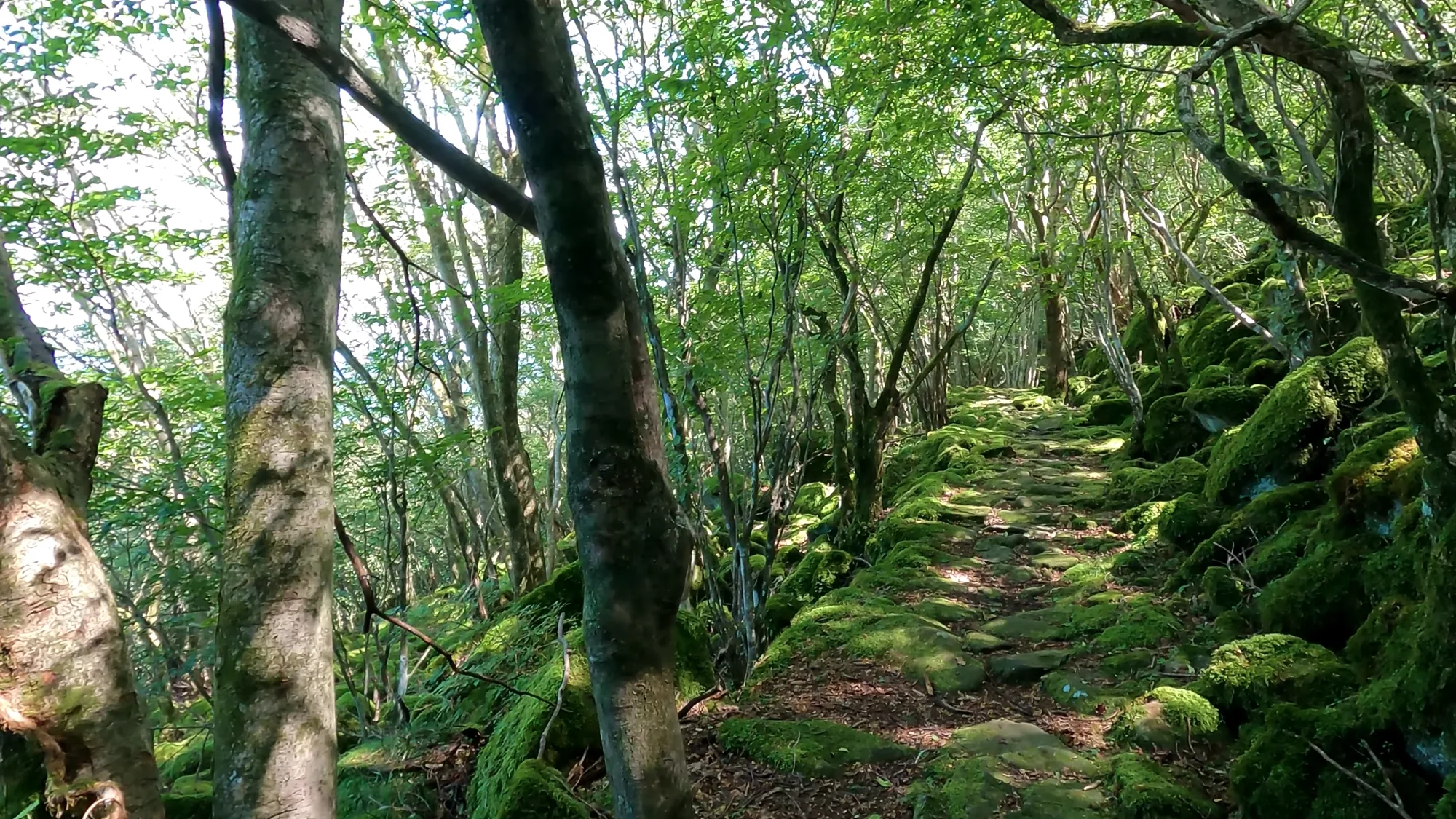
The track contours around the mountain rather than going over it.
The Kiminono reservoir shore course — 10.7 km (6.6 mi), 20 m (66 ft) of height difference. Along the water. Few ups and downs, the entire surface paved, and the city calls it friendly to beginners. In spring about 1,500 cherry trees flower along the shore and on the surrounding hills; in autumn the hills color, against the water. It is the closest course to the city and, they say, the most used.
Hold those three figures together, because they are the whole base in miniature: 300 meters of climb over 5.6 km; 670 over 7.9; and 20 over 10.7. One district, three completely different propositions, all certified under the same name.
The twenty-meter road, and what it means
Ten point seven kilometers (6.6 mi) with twenty meters (66 ft) of height difference, surfaced throughout, is the most genuinely accessible long route in Japan’s certified forests.
Twenty meters over nearly eleven kilometers is an average gradient under two tenths of one percent. That is an order of magnitude flatter than Yoshino’s 1.8 percent, which was the gentlest published figure anywhere. And unlike almost every other forest in the scheme, the surface is stated: paved the whole way.
So when Tsu answers yes on barrier-free, there is something concrete behind it, and anyone planning around a wheelchair has a real candidate rather than a hopeful inference. That is rarer than it ought to be. Kanra answered no while describing a barrier-free course. Yamakita answered no with an easy route buried in its listing. Kitamoto answered yes with nothing published to support it. Tsu answers yes and publishes a paved eleven-kilometer route with twenty meters of climb.
The four questions still apply, because a paved promenade can still have a step at the entrance and no accessible toilet, and they go to the Misugi branch office’s regional development section, on 059-272-8082: the width of the surfaced path, a step at the trailhead, the surface from the parking lot, and the toilets around the reservoir. But this is the one base where you should expect the answers to be good.
The paving, and why it is there
The paving deserves its own paragraph, because stone does not appear on a mountainside by accident.
A laid stone path across a steep slope is built when enough people need to cross it often enough to be worth the labor — pilgrims, pack horses, charcoal burners, villagers going over a pass to the next valley. The stones are set to shed water and to hold under hooves. The result, centuries later, is a surface that has been walked smooth, that holds moisture in its joints, and that grows moss in a way bare mountain soil does not.

The steep section, where the paving turns into steps.
Which is exactly what the city is describing when it says the moss shines after rain. You are looking at a transport engineering decision, made by people who needed to get over this mountain, now covered in bryophytes and listed as a forest therapy road.
Misugi is one of many certified forests whose route is somebody else’s older work — Kōyasan has its pilgrim roads, Mizukami a shrine approach, Kanra a quarry track, Nanasawa the Bandō pilgrimage. Add the Ise Main Highway (伊勢本街道), which runs through Misugi’s Taki district as a post town and which the road station sits in, and the district is laid across two separate pilgrimage systems and a mountain crossing.
Japan’s certified forests are, to a striking degree, old infrastructure with moss on it.
Twelve roads, and what a federated base actually is
The number is worth sitting with. Twelve certified roads is more than twice the average and nearly double the next largest. And they are not twelve variations on one walk.
Each hub has a different landscape and a different reason to exist. Kiminono is reservoir and the hill above it. Taki-Kitabatake is a promenade laid up to a castle ruin, which is to say an archaeological site with a path on it. Mitake-Ōhora is temple approach and mountain. Hikami-Nishiura is forest roads running toward the foot of a thousand-meter peak. Hirakura is a forest road along a clear stream. Hinotani is a hot spring and the walking around it.
Reservoir, ruin, temple, mountain foot, stream, spa. Six completely different propositions, twelve roads between them, one certificate.
What that produces is something no other certified forest offers: a district you could walk for a week without repeating yourself, at wildly different levels of effort, with a hot spring at one end of it. Twenty meters of climb on Monday, six hundred and seventy on Thursday.
And it produces an organizational shape worth naming. Misugi’s base is not run as a program. It is run as a federation, with seven hub subcommittees each operating the courses on their own ground and each running their own events. The city’s role is the certificate and the coordination; the walking is organized by the valleys.

Close to, the moss is deep enough to put a hand into.
That is a sturdier structure than it looks. A base run by one department stops when the officer moves on, which is exactly what happened at Yoshino in Nara. A base run by seven neighborhood committees has seven separate reasons to keep going, and losing one of them does not end the base. If you are wondering which of these forests will still be running in a decade, Misugi’s shape is the most robust of any of them.
The year, and a butterfly that has been here before
All four seasonal fields are filled, which is less common than it should be.
Spring is cherry four ways: the cherry of Mitake on the hundred-best list, the new green along the stone-paved course, the reservoir park’s cherry — and a colony of paperbush, the shrub whose bark is one of the three traditional fibers of Japanese papermaking, and which flowers in tight yellow pompoms before its leaves come.
Summer is one line and it is a festival: the Misugi summer festival and its evening fireworks.
Autumn is the color at the Kitabatake garden and on the Ikenotaira plateau (池の平高原) — and then a place where the chestnut tiger butterfly arrives.
That is the second certified forest to list the butterfly’s arrival as a seasonal event, after Akagi Shizen-en in Gunma, five hundred kilometers (310 mi) northeast. The same migrating butterfly, logged as a seasonal feature by two forests on opposite sides of the country — which is, when you think about it, a small piece of evidence for the migration itself, assembled by accident out of two tourism pages.
Winter is not a landscape at all. It is the burdock festival, designated an intangible folk cultural property by Mie prefecture.
What is actually run here
Three program types are published, and the middle one is the structural signal.

It climbs the trunks too, as far as the rain reaches.
Leave it to the therapist is for small groups, with the content designed by forest therapists, built so you can take the thing slowly and properly.
The hub subcommittee events are the ones that explain the base. Each of the seven subcommittees runs its own, using the courses on its own ground, built around what its own district has. This is not a single program with twelve routes. It is seven neighborhood committees, each running a forest, under one certificate.
Nordic walking is the third, with poles.
The guides’ message is modest to the point of self-effacement: they want many people to feel at ease through the healing power of this nature, and to help visitors unwind slowly through forest walking and forest rest. No measurements, no claims, no mechanism. Alongside the rest of the scheme, that reads less like thinness and more like restraint.
No therapy lunchbox. No price published for anything. Those are the gaps.
Getting there, and the free bicycles
No station, journey time or fare is published anywhere — but Misugi gives a better answer than most, because of one facility.
Hidamari (ひだまり), the visitor information and exchange center, stands in front of Ise-Okitsu station on the JR Meishō line, the terminus of a rural branch, and it does three things: promotes the Ise highway, gives visitor information for Misugi, and offers a rest area with tea served to anyone passing through. And then:
From 09:00 to 16:00, free electric-assist bicycles are lent out.
Misugi cedar, planted for timber and thinned on a schedule since the Edo period.

For a district of 90 percent forest with twelve walking routes spread across six hubs and a branch-line station at one end, a free e-bike is not a gimmick. It is the transport solution, and no other certified forest has provided one.
The other two anchors: the Misugi road station (道の駅美杉), in the Taki district that was a post town on the Ise highway, built entirely of timber so that, the city says, you forget the noise of the town; and the Misugi local history museum (美杉ふるさと資料館) at Kiriyama, whose exhibition is organized around the wisdom of culture, of daily life, and of play in each historical period, with material on the Kitabatake family who governed Ise from here, and the results of the excavations.
So: a branch line to a small station, a free electric bicycle, twelve roads across six valleys, and a choice between twenty meters of climb and six hundred and seventy. Take the paved one along the water if you want eleven easy kilometers (6.8 mi) with fifteen hundred cherry trees over them.
Or go up to the stone paving the morning after rain, walk the smooth old blocks that somebody laid so that people could get over this mountain, look at the moss lighting up in the wet, and, if the summits do not appeal, turn around and come back down. The city has already told you that is allowed.
One last thing about the branch line
The Meishō line deserves a note, because arriving on it changes the visit.
It is a rural branch running inland to Ise-Okitsu, and Ise-Okitsu is the end of it — the train arrives, waits, and goes back the way it came. Lines like this exist in Japan in diminishing numbers; they are expensive to run, carry few people, and survive on a mixture of local necessity and institutional reluctance.
So you come down a line that goes nowhere, to a station at the end of it, where somebody hands you tea and a free electric bicycle. Then you ride into a district that is ninety percent forest, with twelve certified paths in it, laid partly along a highway that carried pilgrims to Ise and partly across a mountain on stone somebody set by hand.
That is a better arrival than a parking lot, and it is available to anyone who looks at the timetable first. The trains are infrequent; check before committing, because the last one back is earlier than you want it to be.
Nearby and alike

Wakayama · Certified 2007
Kōyasan
A monastery has managed this mountain’s trees since the ninth century. One certified road is the ridge women walked when they were forbidden the summit.

Shiga · Certified 2008
Takashima
Three roads on the hills that feed Japan’s largest lake, guides who start at half past nine and tell you exactly why, and a session they will run for one person.

Nara · Certified 2012
Yoshino
The Man’yō poets wrote this valley down thirteen centuries ago. Two certified roads follow the water below the famous cherry ridge, and nobody is running them.