Kumamoto · Certified 2010
Mizukami Forest Therapy Base: Thousand-Year Cedars on a Mountain the Village Calls Mister Peak
Fifty cedars line a shrine path in southern Kyushu, the largest fifty meters tall and ten around. There is no road to them. And in July, a butterfly almost nobody sees.

Wind-shaped trees on an open ridge with layered mountain ranges behind at Mizukami, Kumamoto
Step-free
Not step-free
Both roads climb a sacred mountain from a campsite
The main road
Thousand-year cedar
Ichifusa campsite to the fourth station
The record
What you need to go
Open season
Autumn color on the road and the mountains around it. A public observation meeting for a rare butterfly is held around July. Spring and winter not published
Getting there
not published
Fees
not published
Onsen
Yuyama Onsen Motoyu (湯山温泉元湯) at the foot of the mountain, alkaline and said to be among the highest pH in Kumamoto
The walk
Main trail
The thousand-year cedar long course, from the Ichifusa campsite to the shrine at the fourth station, about 3 hours 30 minutes round trip
All trails
2 trails, the same shrine path taken to two depths. Neither is measured in distance
The step-free road
Barrier-free is marked no, and both roads climb a sacred mountain from a campsite. The campsite at the bottom was refurbished from 2020
The forest
Forest type
A mountain the village addresses by an honorific, with a Heian-period shrine at its fourth station and the cedar avenue leading to it
What grows
Ichifusa cedar, about fifty of them along the shrine approach, in what the guides call primary forest
What lives
Shijimia moorei, a very small protected butterfly. The guides say only that if you are lucky you might meet it
Certified since
2010
All figures updated 5 October 2026
The forest, before the facts
About fifty cedars stand along the approach to a shrine on the side of a mountain in southern Kyushu, and the largest of them is fifty meters (164 feet) tall and ten meters (33 feet) around and has been there for roughly a thousand years. You reach it on foot. There is no road to the shrine and no cable car and no viewing platform; there is a path from a campsite at the bottom, and it climbs through the fourth station of the mountain, and the round trip takes about three and a half hours.
The mountain is Ichifusa (市房山), and the people below it have never called it that in conversation. They call it Otake-san (お嶽さん), Mister Peak, or more precisely the honorific-plus-honorific construction you would use for an elderly relative you were slightly afraid of. It has been treated as a sacred mountain for as long as there is any record of people here, and the shrine at the fourth station, Ichifusa Jingū (市房神宮), was built in the Heian period and is now counted among the cultural properties of the Hitoyoshi-Kuma Japan Heritage designation.
And somewhere in that forest, in July, there is a butterfly that almost nobody alive has seen.
Five reasons to come
Cedars a thousand years old, fifty meters (164 feet) tall and ten (33 feet) around, with no road to them.
A butterfly so rare it is a protected species, with a public observation meeting each July.
A mountain the village addresses by an honorific, with a Heian shrine at its fourth station.
Alkaline water said to have risen here since the Yayoi period, among the highest pH in Kumamoto.

One of the thousand-year cedars on the Ichifusa approach. The oldest are reckoned at well over that.
Game on the menu at the village market, from the forest you walked through.
The cedars you have to earn
The two certified roads here are the same path, measured to two different depths.
The short course runs from the Ichifusa campsite (市房山キャンプ場) at the foot of the mountain up to the second station and back. It is called a moderate distance, and its purpose is put in terms of attention rather than achievement: to feel the mystery of the forest slowly, through the five senses, released for a while from the stress you brought.
The long course, named for the thousand-year cedars, goes from the same campsite to the fourth station and the shrine, and takes about three and a half hours round trip. The description of walking it is unusually physical: you are overwhelmed by the size of them, then healed by the atmosphere, and the tiredness of the mountain path is blown away. That last phrase concedes something. This is work.
The trees are Ichifusa cedar (市房杉), about fifty of them along the shrine approach, and the figures for the largest do not sound real: 50 m (164 ft) tall, 10 m (33 ft) in girth, roughly a thousand years old. Ten meters around is a circle a little over three meters (10 feet) across. Six adults with their arms outstretched, fingertip to fingertip, would struggle to close the ring. One of them is named Senju (千手), the thousand-armed, after the bodhisattva.

Straight for twenty meters, then it gives up and spreads.
There is almost nothing like them in Japan, and the reason is the arithmetic of the site. These are not plantation cedars that happened to be left. They are shrine-approach cedars, planted or spared as an act of religion on a mountain nobody was going to log, on a path that goes up rather than along, in a valley deep enough in southern Kyushu that the commercial forestry which flattened so much of Japan’s old growth never found a cheap way in. The guides call the surrounding stand primary forest.
The butterfly
Then the smallest thing on the mountain, and the rarest.
Shijimia moorei, ゴイシツバメシジミ, is a very small lycaenid butterfly, and it is named in the first line of the forest’s own description of itself, as a rare butterfly. The sentence that follows gives the whole place its character. If you are lucky, you might meet it.
Not you will see. Not home of. If you are lucky.
The whole of the summer season here comes down to one line: around July, an observation meeting for the butterfly is held. A public one. A village of a few thousand people in the mountains of Kumamoto runs an annual gathering for a butterfly most of them will never see either, and that fact tells you more about what sort of place this is than any amount of copy about healing.

The old stand below the shrine, never cleared because of what it belongs to.
What is certain is small. It is rare, it is here, there is a meeting in July, and the people who run the forest think your odds are a matter of luck. Go in July and ask the village about the date.
A mountain addressed as a person
Ichifusa’s claim does not begin with the trees. It begins with the mountain: revered as a sacred peak from ancient times, and addressed by the village as Otake-san.
The shrine at the fourth station is Ichifusa Jingū, Heian-period in origin, and its inclusion in the 人吉球磨 Japan Heritage designation places it inside a story the government tells about this whole river basin: a remote inland region that held onto an unusually dense stock of Buddhist and Shinto buildings precisely because it was difficult to reach, governed for seven hundred years by a single family, and never flattened by the wars that reorganized the rest of Kyushu.
What that means on the path is that the walk has a destination with a reason, which is rarer than it sounds. Most certified roads are loops and out-and-backs engineered to be pleasant. This one is a shrine approach, and it goes uphill because shrines on sacred mountains are uphill, and the cedars line it because that is what you do to a shrine approach. The forest therapy certification was laid over a route that had been walked for a thousand years for an entirely different reason — which is also true at Kōyasan and at Yoshino, and is beginning to look like one of the real patterns in Japan’s certified forests. A surprising number of them are pilgrimage infrastructure with a blood-pressure cuff attached.
What the certificate measures, and what it does not
Mizukami was certified in 2010; the month is not published. The base takes corporate training, overseas visitors and children. It is not barrier-free.
That is the straightforward kind of no. Both roads climb a sacred mountain from a campsite, one of them for three and a half hours, and no amount of goodwill makes that a wheelchair route. The four questions worth asking anyway are surfaced width, step at the trailhead, approach from parking and nearest toilet. They belong to the campsite itself, which was renovated from 2020 and is the only built facility on the mountain. A family that cannot walk the roads can still be in the forest at the bottom of them, and the village office is the place to ask what that looks like.

Almost nothing grows under cedar this old, and what does is shade-hardy.
No result from the certification experiment is published here — no institution, no sample size, no measure, no date. The Society’s criteria require heart-rate variability, blood pressure and pulse, mood by questionnaire and the forest’s impression by semantic differential, taken on the ground in the warm half of the year. Almost no base anywhere publishes what came back.
What Mizukami has instead is a running program, which not every certified base does. The village posted a call for participants in a short-course session on 18 October the previous August; a hiking event around the ten thousand cherry trees of the Ichifusa dam lake; and a spring workshop in the Ichifusa woods. It also publishes a heart-and-body checklist and a list of healing inns — the apparatus of a base that is actually operating.
One program here is unlike anything else on the national list: a women-only forest therapy session, run in May and October, built around Rusie Dutton, the Thai self-stretching practice sometimes called Thai yoga, with a tea break and hammocks. Guiding is by the village’s Ichifusa cedar trekking committee, whose members are versed in nature, history and vegetation — three separate competencies, listed separately, which is a quiet signal that they know the difference.
Water that was here before the shrine
At the foot of the mountain, in the Yuyama district (湯山), is an onsen the village says has been flowing since the Yayoi period.
That is a very large claim, and the village hedges it itself: the water is said to have been rising here that long. The chemistry is firmer. 湯山温泉元湯 is alkaline, the kind called a bath for beautiful skin for the slippery feel of high-pH water, and the village says its pH is among the highest in Kumamoto prefecture. No figure is published.

Early May, about ten days after bud burst, when the whole hill is one color.
High-pH alkaline water does something specific and not mystical: it saponifies the oils on the surface of the skin, which is why it feels silky and why you come out of it feeling scoured rather than merely warm. After three and a half hours up and down a mountain, it is close to the ideal end of the day, and it is at the bottom of the same mountain rather than a drive away.
The other two anchors are at the same foot. The 市房山キャンプ場 sits at the trailhead and has been the public campground since the prefectural park designation of April 1955; it was refurbished from 2020 for people who now expect rather more of a campsite than they did in 1955. And the Water-Above Market (物産館水の上の市場) began as somewhere local farmers could pool what they grew: morning vegetables, handmade manjū, pickles. Its restaurant serves game, and the soft-serve outside is made with milk from a dairy on the Aso caldera.
Game, again. It keeps happening in these mountain villages and it is not a coincidence. A mountain village that still has a forest still has the animals in it, and still eats them, and does not think of that as being in tension with walking slowly among the trees. If the combination sounds jarring, that is a real difference in how the two cultures hold the idea of nature, and it is worth sitting with.
Ten thousand cherry trees, and a village that runs its own forest
Most certified bases are run by somebody other than the municipality — a foundation, a cooperative, an NPO, a tourism association with a desk and a brand. Mizukami runs its own. The forest therapy site is a section of the village’s official website, the contact is the industry promotion section at the village office, and the events are posted by the same people who handle the roads and the water supply.
That has consequences you can see in what gets published. A commercial operator posts seasons and prices. This village posts a call for participants in a short-course session on 18 October, put up in August, the way a community center posts a flower-arranging class. It posts a hiking event around the ten thousand cherry trees of the Ichifusa dam lake — ten thousand, on a reservoir, in a village of a few thousand people, which is the sort of number that only happens when planting trees is something a whole place decided to do. It posts a workshop in the early-spring woods. It maintains a page of healing inns, and another called the heart-and-body checklist, which is a self-assessment tool and not a marketing asset.
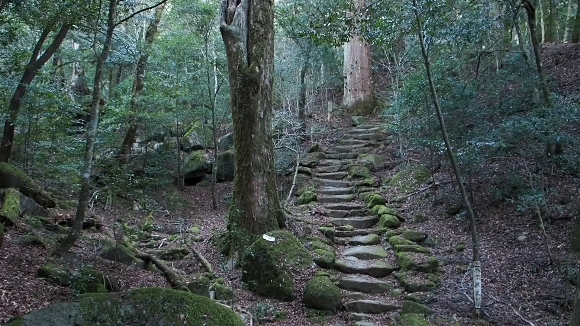
The pilgrim path up Ichifusa, stone-laid where it is steepest.
And it maintains a page listing the other forest therapy bases of Kyushu and Okinawa — a link out to its competitors, on its own site, on the top-level navigation. That is a village that has decided the point is to get people into certified forests rather than into this one specifically, and it is the clearest expression of the federation idea anywhere in the Society’s network.
The downside of being run by a village office is the obvious one. There is no booking engine, no English page beyond machine translation, no published price for anything, and nobody whose job is to answer an email from abroad at speed. The upside is that if you write, a person who actually lives at the bottom of that mountain will read it.
What the Japan Heritage designation is pointing at
人吉球磨 (Hitoyoshi-Kuma) is the river basin Mizukami sits at the head of, and the shrine is one of its constituent cultural properties — a pointer to something larger than one building.
Japan Heritage is not World Heritage and does not work the same way. It does not protect a site; it recognizes a story, and then lists the places that tell it. The story in this case is a region that stayed intact: an inland basin ringed by mountains, governed continuously by one family for about seven centuries, far enough from the wars and the modernizations that rearranged the rest of Kyushu that an unusual density of old shrines and temples simply never got knocked down. Dozens of them survive across the basin. The Heian shrine at the fourth station of Ichifusa is one, and it is among the hardest to reach, which is presumably why it is still up there with a thousand-year-old cedar avenue in front of it.
What this means for a walker is a reframing of the long course. You are not hiking to a view with a shrine on it. You are walking the last and steepest piece of a cultural landscape that extends down the whole river below you, and the trees you have come for are the shrine’s, planted or spared as part of the same act that built it. Take the route in that order: the market and the valley first, the shrine last. The three and a half hours stop feeling like exercise.

Wild azalea on the climb, which flowers for about ten days in May.
Getting there, and the shape of a day
The village office is at 大字岩野90 in Mizukami, Kuma district, 〒868-0795, and the industry promotion section takes inquiries on 0966-44-0314. The village runs the forest therapy program itself, from its own site, with its own event calendar — there is no separate operator company and no booking platform, which is both a limitation and a reason to expect a real person to answer.
No journey time, station, bus route or fare for reaching Mizukami is published anywhere. It is a mountain village at the head of the Kuma river, which is to say inland southern Kumamoto, and the route is a question to put to the village, or to work out from the prefecture’s own transport pages before traveling. This is the real gap: you cannot plan the journey from what is published, so ask before you book.
What can be planned is the day itself, and it assembles neatly. Sleep at the campsite or at one of the village’s healing inns. Start early from the campground — this is a south-facing Kyushu mountain and the middle of a July day on it is not the gift it sounds. Take the long course if you have the legs for it, three and a half hours up to the Heian shrine through the thousand-year cedars, and the short course to the second station if you do not, which is not a lesser version of the walk but a shorter draw of the same water. Watch the understory in July and accept that you will probably not see the butterfly.
Then come down to Yuyama and get into water that has been coming out of this mountain, by the village’s account, since people here were first making pots. Eat something that lived in the forest you have just been walking through.
There are cedars on that path that were already four hundred years old when the first forester in Yoshino started planting, a thousand kilometers (620 miles) northeast, the stands that are still standing there now. Nobody planted these for anything. They were left, because of what the mountain was, and that turns out to have been the most durable forestry policy anyone ever had.
Nearby and alike

Kagoshima · Certified 2007
Kirishima
Japan’s first national park, stone-paved forest with two-hundred-year trees and wild deer, columnar basalt beside the shrine of the gods’ descent — and a guided walk, once a month, for eight hundred yen.

Okinawa · Certified 2007
Kunigami
A subtropical broadleaf forest where seven trees in ten are the same species. Five certified roads, World Heritage since 2021, and cherry in January.

Wakayama · Certified 2007
Kōyasan
A monastery has managed this mountain’s trees since the ninth century. One certified road is the ridge women walked when they were forbidden the summit.

Forest Bathing in Japan
Japan named forest bathing in 1982, then measured it. The practice, the places, and what the studies show.

The Walk
A measured forest walk is about thirty minutes and no destination. Here it is, sense by sense, step by step.

Choosing a Base
Eight forests, from Kusatsu to Yakushima. Which fits your days, your season and the onsen waiting after.