
Narrow path between lavender beds leading toward dense summer woodland at Iwate-machi, Iwate
Step-free
Not step-free
Unsurfaced national forest
The main road
Arashiyama
嵐山 · 2.8 km (1.7 mi) round trip
The record
What you need to go
Open season
Snow still on Himekami in spring while the woods below are in leaf, light through the trees in summer, overwhelming color in autumn. Winter not published
Getting there
not published
Fees
Free, but a mountain-entry notice must be handed in at the Iwate Town Sports and Culture Center next door before you walk in
Onsen
not published
The walk
Main trail
Arashiyama (嵐山), a round trip of about 2.8 km (1.7 mi) through national forest to an observation platform
All trails
3 trails recorded and 2 described, about 2.8 km (1.7 mi) and about 1 km (0.6 mi) round trip. A published plan joins both in 90 minutes
The step-free road
All four service questions are answered no. Both described roads are unsurfaced national forest, and one climbs to a platform
The forest
Forest type
Unsurfaced national forest of red pine and mizunara oak on the fortieth parallel, its floor left deep in fallen leaves
What grows
Midō red pine · Mizunara oak · Cedar · Painted maple · Big-leaf spicebush · Japanese ash
What lives
not published
Certified since
2015
All figures updated 5 October 2026
The forest, before the facts
Before you go into this forest you have to fill in a form.
Not a booking, not a waiver. Both of the certified roads here run through national forest, and entry is free and unrestricted — but the instruction comes twice, once under each road, in the tone of something that matters: when you go in, submit a mountain-entry notice to the sports and culture center next door. It is a slip of paper recording that a person went up and has not yet come down. It is the oldest safety system there is, it costs nothing, and the fact that a town of this size still runs one tells you that nobody here regards a walk in the woods as a trivial act.
What you are entering is a leaf-floor. The Arashiyama road is described in unusually tactile terms: the path is laid deep in fallen leaves, so that walking it feels like walking on a carpet the forest made. Red pine and mizunara oak, with painted maple and ōba-kuromoji and ash underneath. At the top there is a platform, and from it you can see Himekami-san, the Princess God mountain, which in spring still holds snow in its gullies while the leaves below have already come out.
And the town is on the fortieth parallel. That is not trivia; it is the latitude of Madrid, Beijing and Philadelphia, and it is also where the Kitakami river begins, out of a spring called the Bow-Nock. Go in the third week of October, when the leaf carpet is still being made and the view from the platform is the thing everyone photographs.
Five reasons to come
A floor so deep in fallen leaves the town describes walking it as walking on carpet.
The source spring of Japan’s fifth-longest river, in the same town.
A bench in a clearing called Acorn Plaza, which you are instructed to lie down on.
Iwate prefecture’s first outdoor sculpture museum, twenty minutes away.

The therapy road through the hill wood, soft underfoot and flat the whole way.
A mountain-entry form, still filled in by hand, for a one-kilometer (0.6-mile) walk.
A town at forty degrees north
The Iwate Town Forest Therapy Base (岩手町森林セラピー基地) covers the whole of Iwate town, in northern Iwate prefecture, and the first thing said about it is the latitude: it sits on the fortieth parallel north. Towns on that line in Japan mark it, because it is the line where the climate turns — long snowbound winters, short intense summers, and a growing season that forces everything to happen at once.
The second fact is the river. The Kitakami river (北上川) runs 249 km (155 mi), the fifth longest in Japan, and it starts here, at a spring called Yuhazu no Izumi, the spring of the bow-nock, the notched tip of a bow. There is a legend attached to the name. But the fact that reorganizes how you look at the place is simpler than any legend: a river that drains most of a prefecture starts as one spring in one town.
The base itself centers on Yūyū no Mori (ゆうゆうの森), the woodland beside the town’s sports and culture center, the forest arena (森のアリーナ). The stand there holds Midō pine (御堂松), a local red pine, and mizunara oak (ミズナラ), and the whole of it is called an unspoiled forest — in a word that carries a sense closer to innocent than to pristine.
Certified in 2015, Iwate is among the most recent bases in the national system. Set it beside Nukumidaira, certified 2006, nine years earlier, with four published itineraries and a price list, and you can see what a decade of running one does to a base.
Two roads, one of them a kilometer long
Three roads are recorded and two described. Both are in national forest, both are free, and both want the entry slip.
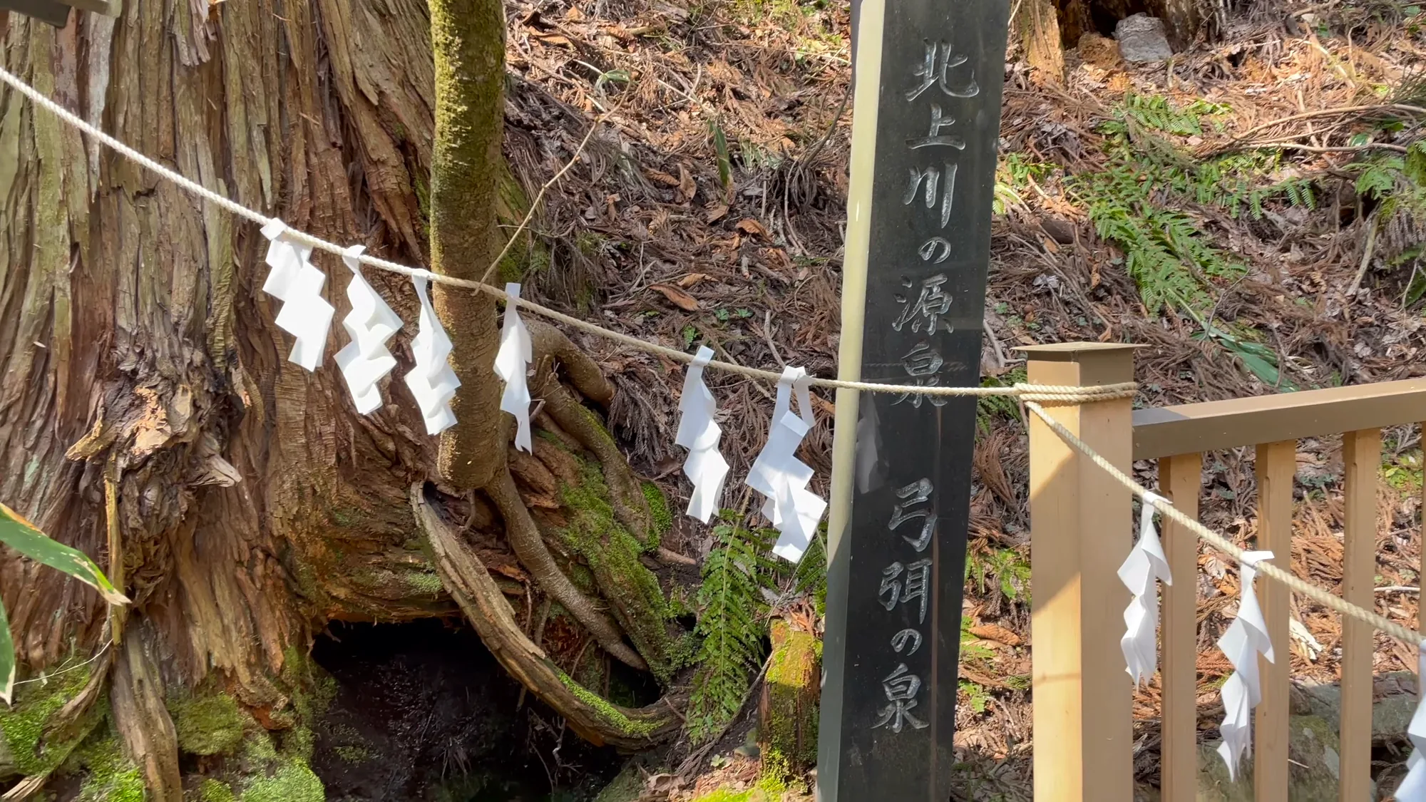
The spring here is counted as the source of the Kitakami river, and the tree above it is roped as sacred.
嵐山 (Arashiyama) is a round trip of about 2.8 km (1.7 mi), climbing through national forest to an observation platform. This is the one with the leaf carpet, and the one with the view: from the platform you can see Himekami-san (姫神山) among other peaks, and the autumn coloring from up there is called overwhelming — the word you use for a performance that silences a room.
The Kodaki course (子抱コース), in Yūyū no Mori, is a round trip of about 1 km (0.6 mi), and the town is refreshingly clear that its virtue is being short: it is the one you can do casually. At its heart is Acorn Plaza (どんぐり広場), and the instruction for what to do there is the best single line anybody has written about any of this. Lie down on the bench, look up at the sky, and breathe deeply, and you can feel the forest breathing.
That is the entire program. No equipment, no measurement, no fee, no guide. Lie on a bench under oaks and notice that something around you is also respiring. For a scheme that certifies forests on heart-rate variability data, it is an unusually confident piece of writing, and it is on the page of one of the smallest bases in the country.
The third road is counted and never named.
The two that are described are, between them, about 3.8 km (2.4 mi) of walking and perhaps two hours if you take them slowly, which is the point. Neither is a hike. The Arashiyama road climbs enough to put a platform above the canopy and no more; the Kodaki road is a loop you could do in a lunch hour and is explicitly built for people who want to go into a wood without making a project of it. On a national list that includes three-and-a-half-hour shrine ascents and five-kilometer (3.1-mile) beech roads, this is the small end, and nobody has dressed it up as anything else.
What the four noes mean here
All four of Iwate’s service answers are no: barrier-free, corporate training, overseas visitors, children.

Mid-July, when the canopy closes over the track completely.
It is worth being careful about what that does and does not mean. The same four noes at Yoshino sit alongside a flat statement that no programs are running. Here they do not. Iwate publishes a therapy plan. A combined Arashiyama and Kodaki route takes about 90 minutes: up the Arashiyama road to the platform, time at the top for the view, then down and across into the Kodaki road, finishing on the bench at Acorn Plaza. It is explicitly designed so you get both roads without walking either of them end to end — a sensible piece of route design that somebody thought about.
So the four noes here describe capability, not dormancy. This is a small base with two unsurfaced forest paths, run by a town office, without English-language provision or corporate-training infrastructure. The roads are open to anybody who files the slip. What is not on offer is a serviced experience in a language other than Japanese.
For a wheelchair user, the honest position is that neither published road is a candidate: one climbs to a platform, the other is a natural woodland path, and the answer on the record is no. The four questions worth asking everywhere (surfaced width, step at the trailhead, approach from parking, nearest toilet) are still worth putting about the forest arena itself, which is a modern sports facility with grounds, and which is the only built thing in the base.
The contact is unusual and tells you how the town thinks about this. It is not the tourism department. It is the Board of Education, Social Education Section, on 0195-62-2111. In the municipal structure of Japan, social education means adult and community learning: evening classes, libraries, local history, things a town does for the people who live in it. Iwate town files its forest under education, not tourism, and after reading the instruction about lying on the bench, that classification feels correct.
The trees, and one of them connects to a cup of tea
The species list is short and worth reading closely, because one entry links this base to another five hundred kilometers (310 miles) southwest.
The conifers are red pine (アカマツ) and cedar (スギ). The broadleaves are painted maple (イタヤカエデ), Japanese ash (アオダモ), the wood used for baseball bats, and big-leaf spicebush (オオバクロモジ), ōba-kuromoji.

The fall above the spring, running hard in the melt and thin by August.
Kuromoji is the aromatic shrub that Takashima, on Lake Biwa, brews into a tea and hands to walkers mid-session as a demonstration of what a phytoncide is. Here it is simply listed as one of the three broadleaves that grow in the stand, with no comment. It is the same genus doing the same chemistry on the fortieth parallel, in a forest where nobody has thought to make anything of it. Crush a leaf between your fingers on the Kodaki road and you will smell exactly what they are selling in Shiga.
The seasonal list is three lines and one blank. Spring is the view from the Arashiyama platform of snow still lying on Himekami-san and Nanashigure-yama while the woods below are in leaf — the specific northern spring, where altitude holds winter in sight for a month after it has left the valley. Summer is sunlight coming through the gaps between the trees, which is a modest thing to put on an official page and is also, if you have walked an oak wood in July, the right answer. Autumn is the coloring. Winter is blank, on the fortieth parallel, which most likely means the roads are not maintained under snow rather than that the forest goes away.
No animal is named anywhere. Given the latitude, the oak mast and the national forest, there is a great deal living in this wood, and none of it is written down. That is a real gap, and better marked than guessed at.
Whose forest this is, and why that explains the form
The detail that organizes everything else about this base is two words: national forest.
Both described roads run through national forest — land held by the state and managed by the Forestry Agency, not by the town. Japan has a great deal of it, something close to a third of all the forest in the country, and most of it is working ground: stands planted after the war, thinned on long rotations, felled and replanted on a schedule set in Tokyo rather than at the town hall.
What that means for a walker here is a set of consequences nobody spells out.

One rock the stream has not managed to move yet.
It explains why entry is free and unrestricted: this is public land and the public may walk on it. It explains why the town cannot surface the paths, widen them, put in a boardwalk or build a toilet at the trailhead, which is why a base with a leaf floor and a view has no infrastructure and answers no on barrier-free: those are not the town’s decisions to make. And it explains the slip of paper. The town is not the landowner, so it cannot control access; what it can do is ask you to record that you went in, at the municipal building next door, so that somebody local knows.
It also explains the forest itself. A national forest stand of red pine and mizunara on the fortieth parallel is not a design; it is what grows here when the Forestry Agency’s plantations meet the native oak, and the word they use for it (unmixed, innocent) is closer to accurate than it would be on a landscaped site. The leaf carpet that is this base’s signature is simply nobody having raked it, for decades, because nobody’s job description includes raking it.
There is a pleasing symmetry in that. The most elaborate bases in the country publish four itineraries, a price list and a stress check. This one publishes a request that you write your name down, on ground it does not own, in a wood it did not plant.
The town of art
The tagline for this base means meeting an unspoiled forest in a town of art, and the art half is real.
The Ishigami-no-Oka Museum (石神の丘美術館) opened in 1993 as Iwate prefecture’s first outdoor sculpture museum. Its grounds, the forest of flowers and art, put sculpture out among planting, so that the works are seen in weather and in seasons rather than in a white room. It is on 0195-62-1453, and it shares its hill with the Ishigami-no-Oka roadside station (道の駅 石神の丘), which has a restaurant cooking local produce, a farm stand and somewhere to sit, run by the town’s own regional development company on 0195-61-1600.
That pairing is the reason to give Iwate a full day rather than ninety minutes. A sculpture park and a forest therapy base are doing a version of the same thing: both are asking you to walk slowly, look at one object at a time, and not hurry to the next. Having them twenty minutes apart in a town of this size is a piece of luck nobody planned.

Snowmelt in April, before anything has leafed out.
The forest arena (森のアリーナ) sports and culture center, on 0195-62-4835, sits directly beside both roads with an arena, a general ground and a hockey pitch. It is where the entry slip goes, and it is worth knowing that the building you file the form in is a working municipal gym rather than a visitor center.
Getting there, and the smallest thing on the list
No station, journey time, bus route or fare is published. Iwate town is in northern Iwate prefecture on the Kitakami river, between Morioka and the prefecture’s northern edge, and the route is a question for the town before you travel. There is no hot spring named in the base’s published material and no therapy lunchbox.
Which leaves a question worth answering plainly: is a one-kilometer (0.6-mile) walk and a ninety-minute plan worth a journey to northern Iwate?
Not on its own, and there is no point pretending otherwise. There are bases in this country with thousand-year cedars, with working bear hunters, with three hot spring districts and an eight-hundred-year cure tradition. Iwate has a leaf-covered path, a bench, and a view of a mountain with snow in its gullies.
But it is on the way to all of that, on the main axis north through Tōhoku, and it costs ninety minutes. And the thing it has that the grander bases do not is a complete absence of ceremony. Nobody will take your blood pressure, hand you a notebook, time your session against the midday phytoncide peak or explain the science. A town will ask you to write your name on a slip of paper so somebody knows you went in, and then it will suggest you lie down on a bench in a clearing named after acorns and breathe until you notice the trees doing the same.
That is the whole practice, stripped of its apparatus, published by a board of education in a town of a few thousand people on the fortieth parallel. Everything else is an elaboration of it.
Nearby and alike

Yamagata · Certified 2006
Nukumidaira
Five and a half kilometers of flat road through two-hundred-year-old beech, in a town that is 95 percent forest — guided, if you ask, by working matagi.

Akita · Certified 2008
Kazuno
Three hot spring districts under one certified forest on Hachimantai, one of them a tōji cure-place for centuries. Beech above, Akita cedar below, and a public bath inside the therapy station.

Shiga · Certified 2008
Takashima
Three roads on the hills that feed Japan’s largest lake, guides who start at half past nine and tell you exactly why, and a session they will run for one person.

Forest Bathing in Japan
Japan named forest bathing in 1982, then measured it. The practice, the places, and what the studies show.

The Walk
A measured forest walk is about thirty minutes and no destination. Here it is, sense by sense, step by step.

Choosing a Base
Eight forests, from Kusatsu to Yakushima. Which fits your days, your season and the onsen waiting after.